What Is Celestial Navigation?
Lots of people have a romantic picture in their mind whenever you mention celestial navigation. It will conjure images of gazing up at the stars, identifying constellations and somehow using that to know where you are.
While the romantic image is partly correct, there is a little more to it than just gazing towards the stars.
Celestial Navigation is the science and art of navigating using celestial bodies like stars, planets, the sun or the moon. Using a sextant, you measure the altitude of celestial bodies to calculate, then plot, lines of position. When three or more lines intersect, you have a celestial position fix.
Celestial navigation is an entire field of study. At one extreme, you can be extremely precise like we have just described, using a scientific instrument like a sextant.
At the other extreme, it is more like an art. A quick glance at Polaris helps you orientate yourself, showing you which way is north.
For example, if you know your destination is towards the east, a quick glance at Polaris may be all you need to show you the way. You are still navigating using a celestial body, so you are undertaking celestial navigation.
The defining characteristic of celestial navigation is just that it is a form of navigation that involves celestial bodies.
The only variable is in the accuracy that you are able to navigate with.
Using better, more precise equipment will give you a higher accuracy than just glancing at the stars at night.
When you use celestial navigation as a professional navigational technique on a cruise ship carrying 5000 people, it is more important to be accurate than if you are taking an evening stroll in the park with a friend.
While both do meet the criteria of celestial navigation, the different applications are the difference between celestial navigation as a science and celestial navigation as an art.
Is celestial navigation a science or an art?
Celestial navigation is both an art and a science.
Science is all about facts, figures and logical processes. In this respect, celestial navigation is a science.
You need to take accurate measurements with a calibrated scientific instrument (the sextant), and an accurate timepiece (a chronometer).
Using the data derived from your instruments, you perform calculations with tables of data, which model the movement of celestial bodies in the sky.
Finally, you plot the result onto a nautical chart to get a position, accounting for errors in your positional lines to give a definite amount of uncertainty.
In this respect, celestial navigation is a “science”.
At the other extreme, you have the more romantic notion of celestial navigation.
Maybe you take a casual look at Ursa Major and use its pointers (Dubhe and Merak) to find Polaris.
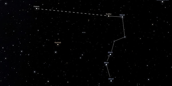
You can then use Polaris as a guide for telling you which way is north.
This form of celestial navigation fits better under the definition of an “art”. Although it is based upon facts, you are using a lot more of your own interpretation.
You are still navigating using celestial bodies, but you are not doing it with any degree of accuracy.
In my view, defining celestial navigation as an art or a science is entirely dependant on the way you are using it and the level of accuracy you need.
In a professional setting, where you are using a sextant and an accurate chronometer to undertake complex calculations resulting in an accurate position, it is definitely a science.
A casual glance up at the stars, using much more of your own intuition, however, it is an art.
Celestial navigation techniques
There are 4 main techniques that I use for celestial navigation:
- 6 star fix using the Marcq St. Hilaire (intercept) method
- Sun-run-sun
- Latitude from Polaris
- Merpass
As we have discussed, there are actually limitless possibilities when using celestial navigation for navigating. The techniques I have listed are the main ones that I use when using celestial navigation as a science. These are suitable when you need a high degree of accuracy with your navigational techniques.
I have written a detailed article about celestial navigation techniques which you can read here: 6 Methods For Celestial Navigation.
Marcq St. Hilaire (intercept) method to fix your position at twilight
The intercept method is the classic method that you imagine when you think about celestial navigation.
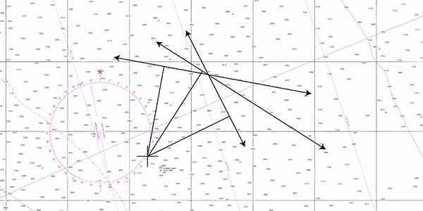
Broadly speaking, you measure the altitude of 6 or 7 stars at twilight, either in the morning or the evening.
This is why they are called “morning sights” or “evening sights”.
You need twilight because the horizon needs to be visible enough to measure from, but at the same time, the sky needs to be dark enough for the stars to be visible.
Once you measure your stars, you compare the altitude that you measure them at to the altitude you calculate that they should be, based on your position.
The difference between the calculated altitude and the actual altitude gives you an “intercept”, allowing you to plot a fix.
It works because you make a “best guess” of your position, then you use the positions of the stars to “correct” that position and make it an accurate fix.
Taking a number of sights at once gives you a number of different lines of position.
As with any navigation at sea, three lines of position are enough to give you a fix.
“Sun-Run-Sun” to fix your position during the day
During the day, the sun is the only celestial body you can use for celestial navigation.
With one celestial body, you can get one line of position. This isn’t enough for a fix, but it is enough to work with to get a running fix.
A sun-run-sun is just a running fix, using the sun to get the lines of position.
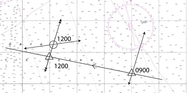
In the same way that you can get a running fix from a lighthouse as you pass by, you can also get a running fix from the sun as it passes.
It is heavily reliant on the accuracy of your vessel’s log and your compass because you use those to transfer one line of position to the same time as another.
Despite the possible inaccuracies, however, a sun-run-sun is the only way of getting a position fix during the day with celestial navigation.
With no other celestial bodies visible, you don’t have another option.
Latitude from Polaris to find your latitude at twilight
The principle of calculating your latitude from Polaris is that Polaris is located at the celestial north pole.
When you are at the earth’s north pole, your latitude is 90°. Polaris will be directly overhead, with an altitude of 90°.
When you are on the equator, your latitude is 0°. Polaris will be on your horizon, with an altitude of 0°.
The same principle applies to all latitudes in between. Polaris’s altitude will match your latitude.
Latitude and longitude by Merpass
Merpass is the meridian passage of a celestial body. This is the point where the celestial body is at its highest point in the sky. For the sun, the meridian passage occurs at midday.
The celestial midday, when the sun is at its highest point in the sky, can be used to calculate your longitude.
You can find the time of celestial midday on the prime meridian using the nautical almanac. Then, you note the precise time of midday at your location using an accurate timepiece.
The difference between the two gives you a “longitude-in-time”, with the difference due to the earth’s rotation.
Using the fact that the earth rotates 15° per hour or 365° per day, you can calculate how far from the prime meridian you are. This is your longitude.
The other feature of merpass is that this is the time of day that the sun will be either directly overhead, directly north of you, or directly south of you.
Taking a normal sight of the sun at the same time will give you a line of position parallel to the earth’s parallels of latitude. It will tell you your latitude.
Using these two techniques together, it is possible to find your latitude and longitude at midday using only the sun.
What is celestial navigation used for?
Celestial navigation is primarily used for navigation at sea when a vessel is out of sight of the land. It is also used when navigating aircraft or space vehicles.
Basically, celestial navigation is used whenever you need to navigate and you don’t have terrestrial features to reference for your position.
If we focus on celestial navigation in the maritime industry, it is used for a variety of purposes.
- Fixing your position when out of sight of the land.
- Cross-checking your GPS to ensure it is operating correctly.
- Monitoring the accuracy of your vessel’s compass.
Commonly, you would imagine celestial navigation being used only for fixing your position. In reality, its most common use is actually for checking the accuracy of your ship’s navigational equipment.
Every watch, navigators will check the accuracy of their compass.
When you are near land, you can use a transit or geographical features to calculate your compass error. Out at sea, celestial techniques are used instead.
Taking an accurate GPS position, you can calculate the azimuth of a celestial body using the nautical almanac. Then, you compare that azimuth to the true bearing of the celestial body. The difference between the two gives you your compass error.
If you discover a small compass error, you can correct the course you are steering to account for the errors in your compass.
Less commonly, celestial navigation is also used for position fixing. Some vessels may navigate with celestial navigation as their primary means of navigation, but it is more common to just use celestial navigation to confirm your GPS is operating correctly.
You don’t necessarily need to take a full celestial fix. Instead, you can just measure a few stars to ensure their altitude corresponds with the altitude you’d expect, based on your GPS position.
If stars appear where you expect them to appear, you can safely assume your GPS is operating correctly.
Is celestial navigation still used?
Celestial navigation is still used by professional and recreational navigators alike.
One of the guiding principles of navigation is that you should never rely on any single method of navigation.
On modern vessels, GPS or any other GNSS (Galileo, GLONASS etc.) is usually used as the primary means of navigation.
Close to land, you can use terrestrial features as a complementary navigation technique to give you redundancy. Out at sea, however, your most reliable back up is celestial navigation.
In fact, it is such an important backup that the US Navy reinstated teaching celestial navigation due to the risk of disruption to GPS signals: Naval Academy Reinstates Celestial Navigation.
Even in the age of GPS, celestial navigation is still taught as a standard part of merchant and naval officer training.
What tools and equipment do you need for celestial navigation?
Accurate celestial navigation requires a sextant, a chronometer, a nautical almanac and sight reduction tables.
There are other tools and equipment that make celestial navigation easier. I have written a complete article on everything you could use for celestial navigation if you want more information. What Equipment Do You Need For Celestial Navigation?
Sextant
The sextant is the most recognisable part of a celestial navigator’s tool kit.
It is the accurate scientific instrument that a navigator uses to measure the altitude of celestial bodies.
Chronometer
A chronometer is an accurate timepiece, used to find the precise time that you take sights with your sextant.
When I am doing celestial navigation, I use a digital watch that I calibrate whenever I can. When the GPS is operating correctly, you can easily calibrate a digital watch to give an accurate time.
Nautical almanac
The nautical almanac is necessary to give you the data you require for celestial navigation calculations.
Nautical almanacs are published annually and contain the positions of celestial bodies for the entire year in question.
Sight reduction tables
Sight reduction tables are needed to transform the data you get from a nautical almanac into data that is useful for performing your calculations.
For example, the almanac will enable you to find the Local Hour Angle and Declination of a celestial body, but you will need sight reduction tables to turn that into an Altitude.
Sight reduction tables can, however, be replaced by a calculator and mathematical formula.
What stars do you use for celestial navigation?
There are 58 stars that are commonly used for celestial navigation.
Rather than list them all here, I have written an entire article about the stars that you can use for celestial navigation: 58 Stars You Can Use For Celestial Navigation.
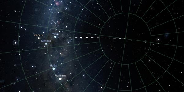
Stars like Polaris, Acrux and Gacrux carry particular significance as navigational stars.
Polaris, for example, is located so close to the celestial north pole that it can be used as an easy way of finding north in the northern hemisphere.
Similarly, in the southern hemisphere, Acrux and Gacrux do the same thing. You can extend the line joining Acrux and Gacrux 4 times to reach an approximation of the southern celestial pole. It isn’t as accurate as using Polaris for the north pole, but it is a good approximation.
Other navigational stars are chosen due to their brightness. To be useful for navigation, stars need to be bright enough to be seen at twilight so that you can measure them while there is still enough light to have a clear horizon.
All navigational stars are listed in the daily pages of the nautical almanac.
Navigational stars need to be listed in the nautical almanac because you need their positional data to perform navigational calculations.
Theoretically, any star could be used if you are able to find its location. Effectively, all you need is a star’s azimuth and its altitude.
Applications like Stellarium (www.stellarium.org) can tell you the azimuth and altitude of thousands of different stars at any time.
Using that, if you can identify a particular star in the sky and measure its altitude with a sextant, you can use the data from Stellarium to calculate your position fix.
How accurate is celestial navigation?
The typical accuracy you can expect from celestial navigation is within a couple of miles.
Accuracy depends entirely upon the accuracy of your sextant and your chronometer. If either of these is incorrect, your final positional accuracy will be similarly reduced.
An error of 1 second on your altitude measurement can lead to an error of 1 mile in your line of position. 1 second is 1/60th of a degree.
Most sextants are accurate to 0.1 seconds, so theoretically they could produce a position line accurate to 0.1M.
In reality, errors also creep in due to small errors in your timepiece, rounding errors in your calculations and small errors in the sight itself.
Resolving these errors gives the typical accuracy of within a few miles.
For a full breakdown of the errors and accuracy of celestial navigation you can read this article which I have written: How Accurate Is Celestial Navigation Compared To GPS?
It is important to remember how accurate celestial navigation needs to be. It is used when you are far out at sea, away from most navigational hazards.
In the middle of an ocean, it doesn’t matter if your position has an error of a couple of miles.
It will be accurate enough to make landfall, at which point more accurate methods of navigation using terrestrial objects can take over.
How to learn celestial navigation
Learning celestial navigation is simpler than most people think.
Starting with the art of celestial navigation, you can use free online resources to learn the positions of some of the stars in the sky and learn about the way stars move.
A great starting point is the free online planetarium, Stellarium (stellarium.org).
You can use Stellarium to become familiar with patterns of stars and learn to identify some of the main ones.
When you are ready to start learning the science of celestial navigation, the best way is to take a short course.
When I learned, it was part of the syllabus for becoming a merchant seafarer. If I was learning celestial navigation again though, I’d take an online course. As I haven’t actually taken one myself, I don’t want to recommend any here.
The main thing is that you only need enough knowledge to get started. The real learning begins when you start doing it yourself and start taking your own sights.
In terms of equipment, the main thing you’ll need to purchase is a sextant. You can see my favourite sextant here: The Ultimate Guide To Buying A Sextant.
For a chronometer, any digital watch will be accurate enough.
Then for an almanac, the best starting point is the free almanac available from thenauticalalmanac.com. I wouldn’t recommend it for actual navigation, but for learning the process it is excellent.
Once you have the basic knowledge, the fastest way to gain proficiency is to practise. When you are out on the water, practise taking sights in the morning and the evening. In the daytime, take sights of the sun every couple of hours.
You just need to do anything you can to practise your skills and develop your own abilities.
Celestial navigation is both a science and an art. Learning it properly will fill you with an immense feeling of satisfaction, and once you have the skills, it is one of those things that you are unlikely to ever forget.