58 Stars You Can Use For Celestial Navigation
There are billions of stars in the sky, most of which are so far away that you cannot see them. In fact, according to the Bright Star Catalogue, there are only around 9096 stars with sufficient brightness for you to see with the naked eye.
Of those, fewer than 100 are sufficiently bright and distinctive enough to be useful for celestial navigation.
Stars that can reliably be used for celestial navigation are listed within the daily pages of Nautical Almanacs. There are usually 57 stars listed, but we also include Polaris on our list as it is so helpful that special celestial navigation techniques can be used.
| Polaris Alpheratz Ankaa Schedar Diphda Achernar Hamal Acamar Menkar Mirfak Aldebaran Rigel Capella Bellatrix Elnath Alnilam Betelgeuse Canopus Sirius Adhara | Procyon Pollux Avior Suhail Miaplacidus Alphard Regulus Dubhe Denebola Gienah Acrux Gacrux Alioth Spica Alkaid Hadar Menkent Arcturus Rigil Kentaurus Zubenelgenubi | Kochab Alphecca Antares Atria Sabik Shaula Rasalhague Eltanin Kaus Australis Vega Nunki Altair Peacock Deneb Enif Alnair Fomalhaut Markab |
Where can you find lists of navigational stars?
Navigational stars are listed within the daily pages of a nautical almanac. Different almanacs do give slightly differing lists. For example, the list of stars in the nautical almanac available from thenauticalalmanac.com includes Scheat, which isn’t shown in other lists.
Within the almanac you are given the tabulated data which you need for celestial navigation calculations. This data includes the siderial hour angle (SHA) and declination (DEC) of each navigational star.
When you are searching for the stars in the sky, it is very hard to find them based on tabulated numbers. What you really want is a map, or a chart.
You can either use a chart of the entire celestial sphere, or you can use localised star charts based on your location.
The easiest way is to use computer software to generate a localised star chart based on your current location.
Stellarium is one such program, which is free and allows you to produce localised star charts.
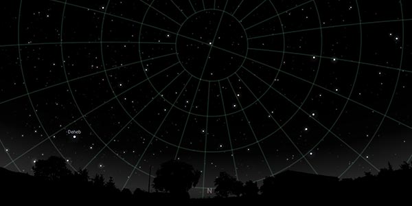
As well as your location, you input the date and time that you plan to complete your observations. The software then generates an image of the sky that you would expect to see at that time.
If you do not have software available, you need to rely on manual methods instead. These don’t give such localised data, but they can still be used to guide you.
The most generic method is to use the standard star chart, that is available inside the nautical almanac itself.
How do you find navigation stars on a star chart?
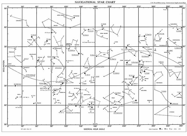
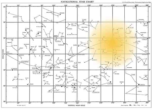
On this star chart, you can see all the navigational stars from our list. It is nowhere near as detailed as the charts you can produce in specialist software, but when it comes to celestial navigation, it gives you everything you need.
Stars are charted individually and joined together with dashed lines showing the constellations.
For example, you can see the constellation of Ursa Major, and the distinctive “panhandle” shape. Within the constellation, the stars: Dubhe; Alkaid; and Alioth are each labelled. This corresponds directly with the list of navigational stars from the daily pages.
Dubhe, Alkaid and Alioth are the three brightest stars in the constellation and are the ones you would use for navigation.
How the star chart works
The stars are charted onto a grid in the same way that the earth is charted onto a grid in a Mercator projection world map.
Instead of the earth’s sphere, the star chart shows the celestial sphere. At the top of the chart, you have the celestial north pole, and at the bottom, you have the celestial south pole.
The celestial poles match the poles on the earth. The celestial north pole is directly above the earth’s north pole.
Similarly, the horizontal line in the middle of the star chart is the celestial equator. Again, this is analogous with the earth’s equator. The celestial equator and the earth’s equator are on the same plane.
Finally, the curved line you can see in the middle of the star chart is the ecliptic. This is the path that the sun traces across the celestial sphere throughout the year.
The reason it is a curved line is that the earth (and the celestial sphere) is tilted, relative to the plane of the solar system. It is this same tilt that causes the seasons.
The sun follows its path across the background stars throughout the year.
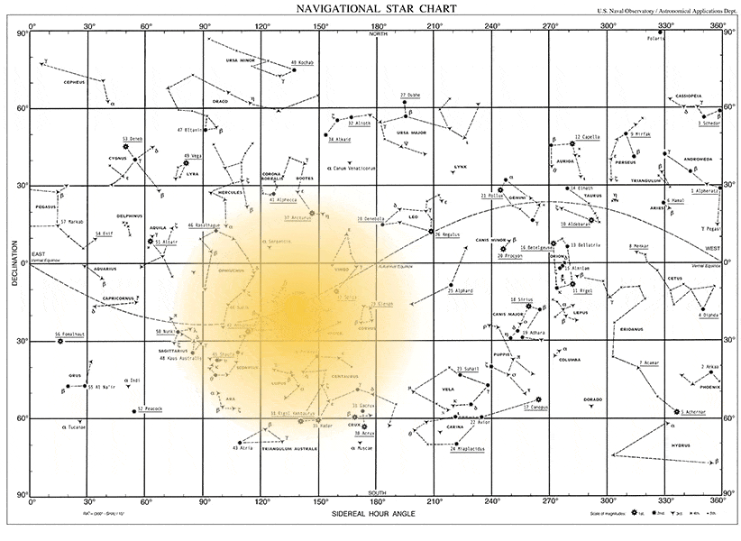
When the ecliptic (the sun’s path) crosses the celestial equator we get an equinox. The vernal equinox is in the spring, and the autumnal equinox is in the autumn.
When the sun is at the highest point on the ecliptic, it is the middle of summer in the northern hemisphere. The lowest point corresponds with the middle of winter.
How to work out which navigational stars are visible
On the star chart, not every star will be visible at any given time. To decipher which stars you can see from any location, we need to consider some further points.
Rotation of the earth
Firstly, the earth is spinning. The easiest way to think about this is to consider how the sun rises and sets every day.
It rises in the east and sets in the west. This tells us that the entire canvas of stars shown on the star chart scrolls across the sky once every 24 hours.
The movement in the animation above is how the sun moves across the celestial sphere over the year. Day-to-day, you won’t notice the sun moving relative to the background of stars.
The rotation of the earth also shows us that the entire star chart is not visible the whole time. You can only see approximately half of the star chart at any one time.
The other half of the celestial sphere is visible on the other side of the world.
In the night time, you cannot see the sun because it is on the other side of the world. The same principle applies to the stars.
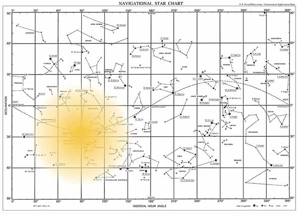
Accounting for day & night on the star chart
Next, we consider what happens in the day and at night. When the sun is visible, it is too bright to see the stars that it is blocking.
The sun masks all the stars behind it.
This is what causes seasonal stars. In the image above, the sun is blocking out some stars, which make them impossible to see at that time of year.
As the star chart scrolls across the sky each day, you will see only the sun during the daylight hours. Then, as the sun sets, stars to the left of the sun will start to appear in the sky.
Throughout the night, the stars will continue scrolling across the sky. The final ones visible will be the ones to the right of the sun, which will then disappear as the sun rises.
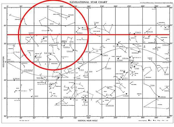
Accounting for latitude on a star chart
The next complication with star charts is to account for your latitude.
The easiest way to think about this is to consider what is visible at the extremes of latitude.
At the north pole, Polaris will be directly above your head and you will be able to see all the northern hemisphere stars.
Similarly, at the south pole, all the southern hemisphere stars will be visible.
On the equator, you would find the northern celestial pole and southern celestial pole on opposite horizons. Throughout the day, the entire celestial canvas would be visible.
Stars on the celestial equator would pass over your head through the day.
At latitudes in between, the same principles apply. We can draw an approximation of this visibility onto the chart.
We start by drawing a line which matches out latitude.

Throughout the day and night, you would expect the stars along this line to pass directly overhead.
Then, you can draw an approximate circle on the chart, illustrating that the canvas scrolls across the sky.
The circle would move across the star chart, from right to left throughout the day.
When the sun falls within the circle, it would be day time and no stars would be visible.
A word of warning
This is a vast oversimplification of what is visible on the star chart.
In reality, the circle that we have used will stretch and deform in the same way the earth is stretched and deformed on a map. On a world map, Antarctica stretched across the entire base of the map, when in reality it is only a small area covering the pole itself.
When at the poles, our circle will instead be a rectangle covering half the star chart.
On the equator, it will be a huge circle covering the entire height of the chart.
Everywhere else, it will be something in between.
None the less, we can use this theory to estimate which stars will be visible and when.
Which stars can you use for celestial navigation in the northern hemisphere?
In the northern hemisphere, you can use the following stars for celestial navigation:
| Polaris Alpheratz Schedar Diphda Hamal Menkar Mirfak Aldebaran Rigel Capella Bellatrix Elnath Alnilam Betelgeuse | Sirius Adhara Procyon Pollux Alphard Regulus Dubhe Denebola Gienah Alioth Spica Alkaid Arcturus Zubenelgenubi | Kochab Alphecca Antares Sabik Rasalhague Eltanin Vega Nunki Altair Deneb Enif Fomalhaut Markab |
The precise stars that you can use will depend on your latitude. Theoretically, you are still in the northern hemisphere if you are just above the equator. We know that on the equator, every star will be visible to you at some point during the year.
In this list, I have included every star with a declination up to 30°S. These would typically be visible if you had a latitude of around 50°N.
As we discussed earlier in the article, the visible stars will also change based upon time of year.
Stars you can use for celestial navigation in the northern hemisphere in summer
In the northern hemisphere summer, the sun is above the celestial equator, near the constellations of Taurus, Gemini and Orion.
In the summer in the northern hemisphere, you can use the following stars for celestial navigation:
| Polaris Schedar Diphda Mirfak Elnath Alphard Dubhe Denebola Gienah | Alioth Spica Alkaid Arcturus Zubenelgenubi Kochab Alphecca Antares Sabik | Rasalhague Eltanin Vega Nunki Altair Deneb Enif Fomalhaut Markab |
Again, this list is highly dependent on your precise latitude and the time of summer.
I have compiled this list based on the northern hemisphere stars we already listed and assumed the ones around the sun’s midsummer location will be obscured.
Stars you can use for celestial navigation in the northern hemisphere in winter
In the northern hemisphere winter, the sun is below the celestial equator, near the constellation of Sagittarius.
In the winter in the northern hemisphere, you can use the following stars for celestial navigation:
| Polaris Alpheratz Schedar Diphda Hamal Menkar Mirfak Aldebaran Rigel Capella Bellatrix Elnath | Alnilam Betelgeuse Sirius Adhara Procyon Pollux Alphard Regulus Dubhe Denebola Gienah Alioth | Spica Alkaid Arcturus Kochab Alphecca Eltanin Vega Deneb Enif Markab |
Again, this list is highly dependent on your precise latitude and the date in winter.
I have compiled this list based on the northern hemisphere stars we already listed and assumed the ones around the sun’s midwinter location will be obscured.
You’ll notice that the list of winter stars is longer than the list of summer stars. This makes sense as the nights are longer in the winter because the sun is in the southern celestial sphere.
Which stars can you use for celestial navigation in the southern hemisphere?
In the southern hemisphere, you can use the following stars for celestial navigation:
| Alpheratz Ankaa Diphda Achernar Hamal Acamar Menkar Aldebaran Rigel Bellatrix Elnath Alnilam Betelgeuse Canopus Sirius Adhara | Procyon Pollux Avior Suhail Miaplacidus Alphard Regulus Denebola Gienah Acrux Gacrux Spica Hadar Menkent Arcturus Rigil Kentaurus | Zubenelgenubi Alphecca Antares Atria Sabik Shaula Rasalhague Kaus Australis Nunki Altair Peacock Enif Alnair Fomalhaut Markab |
The precise stars that you can use will depend on your latitude. Theoretically, you are still in the southern hemisphere if you are just below the equator. We know that on the equator, every star will be visible to you at some point during the year.
In this list, I have included every star with a declination up to 30°N. These would typically be visible if you had a latitude of around 50°S.
As we discussed earlier in the article, the visible stars will also change based upon time of year.
Stars you can use for celestial navigation in the southern hemisphere in summer
In the southern hemisphere summer, the sun is below the celestial equator, near the constellation of Sagittarius.
In the summer in the southern hemisphere, you can use the following stars for celestial navigation:
| Alpheratz Ankaa Diphda Achernar Hamal Acamar Menkar Aldebaran Rigel Bellatrix Elnath | Alnilam Betelgeuse Canopus Sirius Adhara Procyon Pollux Avior Suhail Miaplacidus Alphard | Regulus Denebola Gienah Acrux Gacrux Spica Hadar Fomalhaut Markab |
Again, this list is highly dependent on your precise latitude and the time of southern summer.
I have compiled this list based on the southern hemisphere stars we already listed and assumed the ones around the sun’s southern midsummer location will be obscured.
Stars you can use for celestial navigation in the southern hemisphere in winter
In the southern hemisphere winter, the sun is above the celestial equator, near the constellations of Gemini, Taurus and Orion.
In the winter in the southern hemisphere, you can use the following stars for celestial navigation:
| Ankaa Achernar Acamar Menkar Canopus Avior Suhail Miaplacidus Gienah Acrux Gacrux | Spica Hadar Menkent Arcturus Rigil Kentaurus Zubenelgenubi Alphecca Antares Atria Sabik Shaula | Rasalhague Kaus Australis Nunki Altair Peacock Enif Alnair Fomalhaut Markab |
Again, this list is highly dependent on your precise latitude and the time of southern winter.
I have compiled this list based on the southern hemisphere stars we already listed and assumed the ones around the sun’s southern midwinter location will be obscured.
Which stars can you use for celestial navigation near the equator?
If you were on the equator, over the year every star will be visible to you. The only thing that impacts which stars you see would be the season, corresponding with the location of the sun on the star chart.
Stars you can use for celestial navigation near the equator in northern hemisphere summer
In the northern hemisphere summer, the sun is above the celestial equator, near the constellations of Taurus, Gemini and Orion.
As such, the following stars would be visible and available for celestial navigation near the equator in the northern hemisphere summer:
| Ankaa Schedar Diphda Achernar Acamar Mirfak Capella Canopus Avior Suhail Miaplacidus Dubhe Gienah Acrux | Gacrux Alioth Spica Alkaid Hadar Menkent Arcturus Rigil Kentaurus Zubenelgenubi Kochab Alphecca Antares Atria Sabik | Shaula Rasalhague Eltanin Kaus Australis Vega Nunki Altair Peacock Deneb Enif Alnair Fomalhaut Markab |
Stars you can use for celestial navigation near the equator in northern hemisphere winter
In the northern hemisphere winter, the sun is below the celestial equator, near the constellation of Sagittarius.
As such, the following stars would be visible and available for celestial navigation near the equator in the northern hemisphere winter:
| Polaris Alpheratz Ankaa Schedar Diphda Achernar Hamal Acamar Menkar Mirfak Aldebaran Rigel Capella Bellatrix | Elnath Alnilam Betelgeuse Canopus Sirius Adhara Procyon Pollux Avior Suhail Miaplacidus Alphard Regulus Dubhe | Denebola Gienah Acrux Gacrux Alioth Alkaid Hadar Kochab Shaula Eltanin Kaus Australis Vega Deneb Markab |
Using stars for celestial navigation
Throughout this article, we have discussed which stars you can use for celestial navigation.
The complete list of 58 stars covers everything that has the potential to be used as a celestial navigational star.
Seasonal and positional lists break it down into stars that have the potential to be used at different times of the year and in different locations.
You can create your own list based on your location and the techniques we described for blocking out sections of the star chart at different times of the year. You just block out the part corresponding with the sun’s location.
When it comes to navigating with these stars, however, there are further considerations that you need to take into account.
Navigational stars shouldn’t be close to the horizon
Any star that you use for celestial navigation should not be close to the horizon.
The closer a star is to the horizon, the less accurate your eventual fix is going to be.
This is because a sextant can measure the altitude of a star easiest when it is between about 20° and 60° in altitude.
Looking at the star chart, this eliminates a lot of the stars at the extreme edges of the visibility circles.
For example, on the equator, although Polaris may be visible, it will be so close to the horizon that it won’t be the best navigational star for getting a line of position.
Navigational stars shouldn’t be too high
Similarly, stars that are high in the sky also should not be used for navigation.
While the sextant can measure angles up to 120°, it is hard to get a good line of position from a star above 60° altitude.
The closer a star is to your zenith, the less accurate your eventual fix is going to be.
Ideal stars for celestial navigation
For every position and time, there are a few stars that are better than the rest for celestial navigation.
Although there are 58 possibilities, usually you will find that around 7 are optimal for the fix you want to take.
These best stars are published in “Rapid Sight Reduction Tables”, and can be used as a quick way of undertaking celestial navigation.
The use of these tables is complex, however, so that is a topic for another article.