What Equipment Do You Need For Celestial Navigation?
Celestial navigation is all about using the stars and celestial bodies to find your position. In the middle of the ocean, it is really your only viable option as a backup to GPS. To be able to complete a celestial fix, however, there are some essential tools that you will need.
- Sextant;
- Chronometer;
- Nautical almanac;
- Sight reduction tables;
- Nautical tables;
- Sight proformas;
- Scientific calculator;
- Nautical charts;
- Plotting sheets.
Sextant
The sextant is a scientific instrument that uses the double reflection principle to measure the angle between two objects. With celestial navigation, we use it to measure the angle between the horizon and a celestial body. The angle measured is the altitude of the body, which we then use within our calculations to calculate lines of position.
You could use your sextant to measure any celestial body: the sun; moon; planets; or stars. Irrespective of which body you choose, the sextant is the instrument that you need to find its altitude.
Sextants come in two broad categories: ones with a metal frame; and ones with a plastic frame. Metal frame sextants are often significantly more expensive than plastic ones. They do, however, offer more durability, and are generally considered to be more accurate. Plastic sextants are generally better for beginners because they are more affordable and lighter to hold for extended periods of time.
It doesn’t really matter which sextant you use. I have used both metal and plastic sextants to achieve acceptable positional accuracy. You can read more about the accuracy achievable in this article where I compare the accuracy of celestial navigation to the accuracy of GPS: How Accurate Is Celestial Navigation Compared To GPS?
Personally, I think you should just buy whichever sextant is most suitable for your budget. Don’t feel that you need to spend extra to get a metal frame because you have heard they are more accurate. If you want to know which one I currently use, read about my favourite sextant.
Chronometer
A chronometer is an accurate timepiece. The term “chronometer” conveys that a particular timepiece meets vigorous standards of precision and accuracy.
In reality, you will probably replace the chronometer with a watch that is kept as accurate as possible. Most digital watches today will be accurate enough to meet your needs.
Pro Tip: Use your GPS to set your watch accurately so that it is already accurate if your GPS ever fails.
My favourite is a simple Casio watch that is available cheaply around the world. It gives a simple digital readout of hours, minutes and seconds so it is easy to write down as soon as you take your sight. Whichever timepiece you choose, make sure it displays seconds as well as hours and minutes. At the equator, the earth moves at about 500m/s so even a few seconds of error can give you a few miles of error in your position.
Almanac
A Nautical Almanac is a book that gives you the position of stars, planets, the sun and the moon in the sky. There is a new almanac published every year, giving you all data you require for celestial navigation for that year.
The official nautical almanac is published in collaboration between the United States Nautical Almanac Office and the United Kingdom Hydrographic Office. For training and learning purposes, however, I recommend you check out TheNauticalAlmanac.com who calculate and distribute their own pdf nautical almanac for free.
Regardless of which almanac you use, each one is broken down into different sections.
The daily pages
The daily pages contain the positions of celestial bodies for every hour of the day throughout the year. They are the pages you need to use to calculate the local hour angle and declination of each body you are measuring with your sextant. It is the equivalent of giving them latitude and longitude so that you could plot them on the celestial sphere.
In addition to data about stars, planets, the sun and the moon, there are also tables for sunrise and sunset. These, along with the tables for twilight, are important for planning your sights. You need this data to plan ahead so that you are prepared to take your sights at the correct time.
Increments and corrections
Complementing the daily pages, you get pages for increments and corrections. These don’t change from year to year. If you have increments and corrections from another source, they will be just as good.
The increments and corrections let you interpolate between the hourly data given in the daily pages. For example, the daily page might give the data for Jupiter at 08:00 UTC and 09:00 UTC. You can then move to the increments and corrections to find a correction to apply to get to 08:31:25 UTC.
The purpose of the increments and corrections is just to minimise the amount of information that needs printing on the daily pages.
Altitude correction tables
The altitude correction tables give you corrections for your height of eye; refraction; temperature; and atmospheric pressure.
These corrections apply throughout the year so are only printed once in the almanac. It saves printing the same data on every page.
Sight reduction tables
Sight reduction tables are optional. They are books containing huge tables of data for turning the information you get from an almanac into data specific for your location. While the nautical almanac gives the position of celestial bodies on the celestial sphere, sight reduction tables are used to transform those into positions relative to you.
Sight reduction tables are traditionally carried on ships as they allow you to do celestial navigation without a calculator. If you want to do celestial navigation in its purest form, they are essential. The disadvantage is that the books containing the tables are heavy volumes which can take up a lot of space.
Sight reduction tables are available as a pdf from TheNauticalAlmanac.com so you can download them to practise with instead. If you do use the pdf though, you are still relying on electronic equipment to display the pdf. Once you accept you want to use something electronic to display a pdf, I’d rather go down the route of using a scientific calculator with my proformas and forget about the reduction tables completely.
Nautical tables
Nautical tables are also optional. They are used in a similar way to sight reduction tables, except they are more mathematical. You can carry one book of nautical tables instead of multiple volumes of sight reduction tables.
It is more complicated to use nautical tables than it is to use sight reduction tables, but it is less to carry onboard.
Popular examples of nautical tables are Norries Nautical Tables or Burtons.
Again, I actually prefer to use a scientific calculator rather than carry nautical tables.
Sight proformas
Proformas are optional. I prefer to take my own proformas to use with a calculator rather than taking a full set of sight reduction tables or nautical tables.
A proforma is just a sheet to work through to make your calculations easier. If you are doing celestial navigation on a daily basis, you will find that you remember everything that you need to do and all the equations you need. If you are like me, and you spend a few months at a time away from celestial navigation, an easy proforma does help.
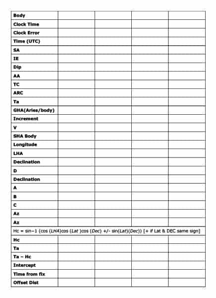
I made all of mine when I first started learning celestial navigation. You can see that this one is written in such a way that I can take it onto the deck with me and shoot all my sights. I can then work through the rest in the cabin and come up with all the information that I need to plot my fix.
It is good practice to make your own set of proformas because it helps you to visualise the process that you will walk through when you take your sights. Having made your own, you will always find it easier to come back to it, even if you spend many years away from the sea.
Calculator
A calculator is optional. I always take a scientific calculator with me so that I can use my proformas to calculate my position rather than relying upon sight reduction tables or nautical tables.
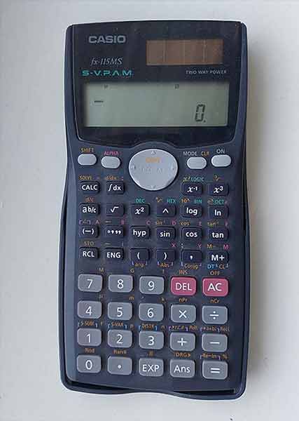
When you select your calculator, just make sure it is a full scientific calculator that is capable of working with trigonometry and brackets. If you get one with a small solar panel, it should always have enough power to operate without you needing to remember batteries.
I have used a Casio FX-115MS for the past 20 years, but any similar model will be sufficient. Just make sure you are familiar with your own as it is easy to make a mistake when typing in all the numbers you will need. Ideally you will have the ability to go back and change a number within a formula as it can quickly get frustrating if you make a mistake and can’t change it.
Nautical charts
You should already have nautical charts with you as part of the vital navigational gear on your boat. You will need to use them to plot your final fix.
For training and practise, nautical charts are not strictly necessary because you can work out your fix mathematically. When I was training, the ships I was on were fully electronic, meaning they had ECDIS rather than paper charts. I would complete my plot on a piece of paper, and then use trigonometry to work out the latitude and longitude of my fix. If I could have used paper charts, it would have saved me time because I could skip those final steps as the plot would have been directly onto the chart.
Paper charts are particularly useful if you are completing your fix on a larger scale chart. This would be the case if you are closer to the land. Larger scale charts are zoomed in closer, giving you more detail to be able to plot your lines of position accurately.
Conversely, if you are plotting in the middle of the ocean, you will most likely be using a small scale chart. It is a lot harder to get an accurate fix on a small scale chart because it is zoomed out so far. Saying that, if you are in the middle of the ocean and using a small scale chart, it is likely you do not need too much accuracy on your fix anyway.
Plotting sheets
Plotting sheets are optional. If you are able to plot onto a nautical chart, you have no need to use plotting sheets at all.
Plotting sheets allow you to plot your fix onto the sheet and easily read off the final latitude and longitude. They compensate for the fact that parallels of longitude are not actually parallel due to the curvature of the earth. 1 degree of longitude at the equator is not the same distance as 1 degree of longitude closer to the poles.
When I was learning celestial navigation, I didn’t use any plotting sheets. When I was completing my plot on a sheet of plain paper, I would keep everything in miles. I ignored the latitude and longitude until the final step. Once I had my fix, I took the range and bearing between the fix and my estimated position. I knew the latitude and longitude of my estimated position, so I could use plane sailing techniques to calculate the latitude and longitude of my fix.
Had I had plotting sheets when I was training, I could have saved some time in those final steps. The result would have been the same, but I wouldn’t have needed to complete the extra bit of trigonometry.
What equipment is essential for celestial navigation?
We have talked a lot about all the gear that you need for celestial navigation. Along the way, you’ll have noticed I said a lot of bits were actually optional. Once you strip out all those optional elements, you are left with a few items that really are critical for completing a celestial fix.
The sextant, to actually take the sights.
A nautical almanac to calculate the real positions of celestial bodies so that you have a reference point to calculate your position.
Either a calculator and proformas; or a set of sight reduction tables; or a set of nautical tables. Whichever you pick, these will be used to turn the data from the almanac into useful information for working with.
Finally, you need the chart that you are using to monitor your passage. You just need a way to actually plot your final fix, and as you should have a chart with you anyway you may as well plot straight onto that.