Seapilot vs Navionics: An Ultimate Comparison
Seapilot was one of my favourite apps when I tested multiple marine navigation apps on a recent sailing trip.
But it got me wondering, how does it stack up against the undeniably popular, Navionics?
Seapilot is more powerful and more customisable than Navionics, but Navionics was still my favourite. The Navionics app matches most of Seapilot’s functionality, but is more refined, has a bigger community and just looks more visually pleasing on a mobile device.
Don’t get me wrong, I love using Seapilot. It offers so much functionality in terms of NMEA integration, vector personalisation, and chart customisation.
I think I liked Seapilot so much because it felt familiar to me. I am used to navigating commercial vessels with integrated bridge systems. The experience of Seapilot was almost like an integrated bridge, in an app.
The Navionics app, however, felt like it was designed specifically as an app. It has clearly been optimised for use on a tablet or mobile device.
The menus in Navionics are better designed for use on a touch-screen, and the navigational data display is better thought out, displaying everything you need around the edge of the screen.
I felt like Seapilot would act as a better replacement for a complete navigational solution, but that meant that there was almost too much functionality for an app because it needed too many menus.
In an app, you want an easy interface and to have all the information you need at your fingertips. Apps are not a replacement for traditional navigation but are meant as a supplementary tool.
Seapilot felt like a commercial ECDIS on a tablet, but Navionics felt like a specifically designed tablet chart plotter.
Navionics makes the most of its popular market position, capitalising on user-generated data to add an extra dimension to its charts.
User-generated information cannot be relied upon, but it is as useful as chatting to a local down at the pub. You can get some great insights about popular spots, fishing locations and nice anchorages.
Overall, Seapilot is a better app if you want a technically good program that could rival a commercial system. Navionics is better if you want an app to help make your sailing more fun.
If I was choosing one for my own boat, I would choose Navionics.
Seapilot and Navionics are two great apps for marine navigation, however, they are not your only choices. You might be interested in my full comparison to see other options: Top 8 Apps For Marine Navigation.
What is Seapilot?
Seapilot is a highly capable recreational boating app, by Raymarine.
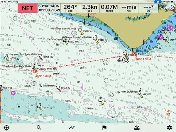
On starting the app, I felt like I was using professional software due to the shading used by the chart and the level of customisation that was possible.
Seapilot gives you a good amount of control over the different layers that its chart displays, allowing you to turn off things if the screen starts to look overly cluttered.
At the top of the screen, you can customise the navigational data that is permanently displayed so that you get easy access to the information you want.
The app’s pricing is split, so you get the basic app for free and then you can purchase all of its features as a “Premium” subscription.
Although you can use the basic version, some essential things like “Routes and Waypoints” are a “Premium” feature, so it led me to assume that the basic cost of the app is the premium subscription of $39.99/yr.
The biggest downside that I found with Seapilot was that the data displayed on the main screen was not as comprehensive as I needed.
I frequently needed to open menus at the side so that I could see all the information that I wanted.
Despite that, I was very happy with Seapilot, and would happily recommend it for use by recreational boaters.
If you are considering purchasing Seapilot, you may be interested in my full review: Seapilot: Reviewed By A Professional Navigator.
What is Navionics?
Navionics is a recreational maritime charting application produced by Garmin.
It is incredibly popular within the community, having topped several polls of the most popular charting applications.
The Navionics community is one of its greatest assets, giving a unique additional data source that is unmatched by its rivals.
Community edits on charts give you an extra level of local knowledge that just isn’t available elsewhere.
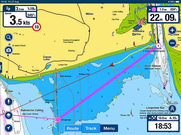
When the app is running, it is one of the easiest and most intuitive to use.
The chart itself is clear and easy to read, with lots of additional information placed around the edge of the screen.
It was immediately obvious that the app has been well designed and continuously refined by those that are actually using it.
Passage planning in Navionics is simple and intuitive. You simply tap along the chart in a line to create your route, and that is pretty much it.
The biggest downside that I found with Navionics was its simplicity. For most users, it might be considered a good thing, but I would have liked a little more control than I was actually given in terms of the chart and route customisation.
If you are considering purchasing Navionics, you might be interested in my full review: Navionics App: Reviewed By A Professional Navigator.
Seapilot vs Navionics: Which wins on price?
Winner: Navionics
Seapilot and Navionics are both free to download, but then their pricing structures then differ.
With Seapilot, you can upgrade the basic app to “Premium” for $39.99 to unlock its additional features. In addition, you will need to purchase a subscription to the charts that you want to use.
With Navionics, additional features are unlocked automatically with any chart subscription.
With both apps, I purchased charts for my local area and spent:
| Navionics (UK, Ireland & Holland) | £34.99 ($35.99) |
| Seapilot (Great Britain) | £17.49 ($25) |
Both packages allowed me to use the same chart subscription on my phone as well as my iPad.
Essentially, Navionics charts were more expensive on an individual basis but did not need a premium subscription.
Seapilot might work out more cost-effective if you need to purchase multiple different chart areas.
Most recreational boaters will be like me, and only actually need to purchase charts for a single area.
In that situation, Navionics works out cheaper.
Seapilot vs Navionics: Which is best for passage planning?
Winner: Seapilot
Passage planning in both apps was easy and intuitive. I did not need to consult the documentation for either app to complete my passage planning.
With both apps, your passage plan consists of placing a series of waypoints to create a route.
Seapilot holds a slight advantage over Navionics in this regard because the waypoints you place are offset from your finger.
This allows you to see exactly where the waypoint will be located before dropping it on the chart.
Navionics will just place the waypoint underneath your finger. It is fine, and a well-accepted way of doing it, but means you may find it hard to precisely place points in comparison to Seapilot.
While planning, the menus in Navionics look more modern and better designed for a tablet screen. Seapilot menus are good, and they do display everything that is needed, but they look and feel more technical than those in Navionics.
Overall, I would say that Seapilot wins over Navionics for passage planning, however, if you like a “friendlier” looking screen then you will prefer Navionics.
For me, I am used to passage planning on commercial ECDIS screens, so Seapilot felt more familiar.
Seapilot vs Navionics: Which is best for navigation?
Winner: Navionics
In navigation mode, Seapilot and Navionics both give a great view of the chart, clearly showing your own vessel’s position and heading.
The biggest difference between the two on their main chart navigation screen is that Seapilot gives you control over your vector length.
You can set the number of marks along the vector, and the time period of each mark.
Navionics does not give you such control, so the line is a heading line rather than a vector.
Speed and course are clear in both apps, but Navionics does a much better job of displaying additional information.
Around the edge of the screen in Navionics, you can clearly see course and distance to the next waypoint, as well as DTG and TTG to the end of your route.
To get the same information in Seapilot, you need to open up the side menu and look for the data in there.
In navigation mode, you get the feeling that Navionics has been designed as a tablet app from the very beginning, and continuously updated to reflect the user experience.
I got the impression with Seapilot that, although all the data is there, it is slightly less well refined in the way that it is presented.
Overall, for navigation, I prefer Navionics.
Seapilot vs Navionics: Which one is best?
Winner: Navionics
Seapilot and Navionics are both great apps for using your mobile phone or tablet as a chart plotter.
When I put them to the test, Seapilot was in the first batch that I tested, and I was so impressed with it that I didn’t think it could be beaten.
On the day I tested Seapilot, I kept returning to it while testing other apps because I liked it so much.
The next day, I tested Navionics and immediately saw how well refined mobile navigation apps could be.
Every small annoyance about Seapilot, like pulling up the menu to find some information, was solved in Navionics.
I did genuinely like both apps for navigating on my boat, but I was left with the impression that Navionics is better designed for use on a tablet.
There is undeniably better functionality in Seapilot, with more customisation options, more NMEA connections and better internet AIS. So, from a purely technical point of view, Seapilot would be the winner.
As a supplementary app on a small boat, however, I did prefer Navionics because of its user interface and the way it displays the exact data a small boat owner would want.