Navionics App: Reviewed By A Professional Navigator
I recently decided that I wanted to try using my phone and tablet as a chart plotter.
On checking the various app stores, I found numerous different solutions and struggled to choose between them.
In the end, I purchased a load of them so that I could independently test and compare them all.
One of the apps that I tested was the incredibly popular, Navionics, by Garmin.
Navionics is one of the best apps for using your tablet or mobile device as a chart plotter. It is incredibly easy to use and competitively priced, especially considering that a single subscription will allow you to use the app across all your devices, whether Apple or Android.
| Positives | Negatives |
| Excellent pricing | Limited NMEA interface |
| Easy to use | Limited chart layers selection |
| Great tidal information | |
| Excellent navigation screen | |
| Cross-device operation |


The Navionics Boating App is free to download, then you just purchase the charts that you want to use.
Purchasing the charts unlocks all of the app’s features, and permits use across all your devices that are logged in to the same Navionics account. I used the same subscription on my iPad and Android phone.
Using the app is easy and intuitive, so you can quickly start planning your passages and easily follow them when out on the water.
When I tested Navionics, I did not need to consult the user guide at all. Any time that I was unsure, a hint was already written on the screen so it has clearly been well refined for ease of use.
In navigation mode, Navionics showed all the information I needed around the edge of the screen so you do not need to open additional menus to find the data you want.
As it is so well designed, you barely notice the lack of customisation available. Compared to other apps, you are quite limited in what you can do.
You cannot control many chart layers, and you cannot use NMEA data that the app is not already displaying.
Overall though, the lack of customisation was not a problem for me as I liked everything just as the app presented it to me.
Navionics is a very popular app, with over 1M downloads in the Play Store.
The wide user base has allowed them to utilise “Community Edits” providing an extra dimension to your boating experience, unavailable in less popular apps.
I would happily recommend Navionics Boating App, and will likely continue to use it on my own boat.
If you are considering purchasing Navionics, you might first want to consider reading this article where I compare the 8 different navigational apps that I used during my sailing trip: Top 8 Apps For Marine Navigation (Judged By A Navigator).
Navionics App pricing
Navionics works in a similar way to most other navigational apps. The app is free to download, then you pay for the charts that you want to use.
The great thing about Navionics is that subscribing to a chart area automatically activates all features within the app. You do not need to factor in any additional “Premium” fee.
In my case, I purchased a pack of “UK, Ireland & Holland” charts for £34.99 ($35.99 US).
At the time of writing, a selection of their different pricing is as follows:
| Chart Area | US $ | GB £ |
|---|---|---|
| UK, Ireland & Holland | $35.99 | £34.99 |
| US & Canada | $21.99 | £20.99 |
| USA | $14.99 | £14.99 |
| Mexico, Caribbean to Brazil | $28.99 | £26.99 |
| Central & West Europe | $27.99 | £26.99 |
| Australia & New Zealand | $21.99 | £20.99 |
| Baltic Sea | $39.99 | £34.99 |
With Navionics, the subscription lasts for 1 year, after which you can still access your previously downloaded charts but you will no longer receive updates.
The other great thing about Navionics is that a single subscription will work across multiple devices. I purchased charts on my iPad, and could use the same subscription on my Android phone.
As long as you log in to the same Navionics account on all of your devices, the same subscription applies across all platforms.
In terms of pricing, Navionics was one of the most competitive out of all the apps I tested.
What charts does Navionics use?
Navionics uses vector charts based on data from national hydrographic organisations, public and private surveys and data reported by users.
Navionics actually manufacture their own nautical charts, so the same data is available in other apps that I have reviewed. For example, in iNavX.
As Navionics uses vector charts, you can perform a few customisations to get the charts looking how you want.
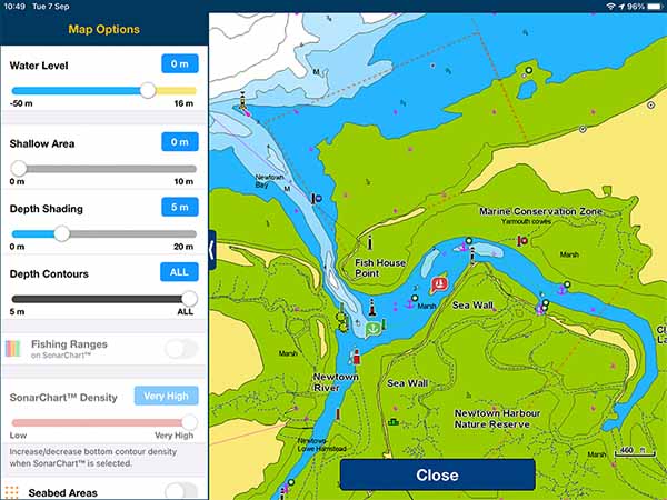
The main customisation available is for different depth contours and shading levels at different depths.
Unfortunately, in comparison to other apps, chart customisation within Navionics is very limited.
You cannot customise different layers of data in the chart, so you cannot toggle things like light sectors, anchorage area etc. All layers will be turned on at all times.
Although it would be nice to have the ability to toggle layers, with electronic charts you should always navigate with as many layers turned on as possible.
You should only consider deactivating layers when your screen becomes so cluttered that it hinders safe navigation.
With Navionics, I never found my screen cluttered. The display seemed to be well designed, so there was actually no need to turn layers off.
You can toggle additional features like “Community Edits” or “ActiveCaptain Community”, however, I left both turned on because they proved useful.
For example, when I anchored for the night, I noticed there was a community edit telling me the cost of mooring buoys, and giving a little information about the procedure.
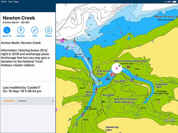
With a popular app and community, Navionics really seem to be making the most of the data available to them, and it does make for a great chart user experience.
Downloading charts with Navionics
Navionics works without an internet connection as long as you have downloaded the charts you require beforehand.
There are two ways to download charts in Navionics.
Charts download automatically for areas that you browse while you are connected to the internet.
This is particularly useful if you have planned your passage at home in advance. Planning on WiFi automatically loads all the charts you need onto your device.
Alternatively, you can go into the “Download Maps” section of the menu and manually select the area you which to download.

Passage planning with Navionics
Passage planning in Navionics is easy and intuitive. I did not need to consult the user manual at all while I was passage planning.
To create a route, you simply tap on “Route”, then select whether you want an “Automatic” or a “Manual” route.
For my passage, I used manual routes, but I did try automatic routing as well and found it did an adequate job of getting me to my destination. I just prefer to have full control of my routes when planning.
Once you select the route that you want, Navionics tells you to “Tap and hold the map to add waypoints”.

Repeating the process creates multiple waypoints, which together make up your route.
You can then save the route to your account with a name of your choice.
The great thing about saving routes to your account is that they are immediately accessible on all your connected devices. I planned the routes on my iPad, and could immediately see the same route on my phone.
This would not work when using my devices offline, but assuming you plan your passages at home before your trip, they should be accessible across all your devices.
Navigating with Navionics
Navigating with Navionics is easy and intuitive. You simply have the route that you want to follow open, then click “Start”.
Navionics will use your device’s GPS to plot your position, course, and speed onto the chart.
When I used my iPad, I discovered that WiFi-Only iPads do not have an integrated GPS. You need to buy an external Bluetooth GPS to use Navionics. You can read my review of my GPS here: Garmin GLO 2 Review.
If your device has an integrated GPS, Navionics will work straight away.
Alternatively, you can connect Navionics to your own boat’s equipment through a NMEA to WiFi gateway.
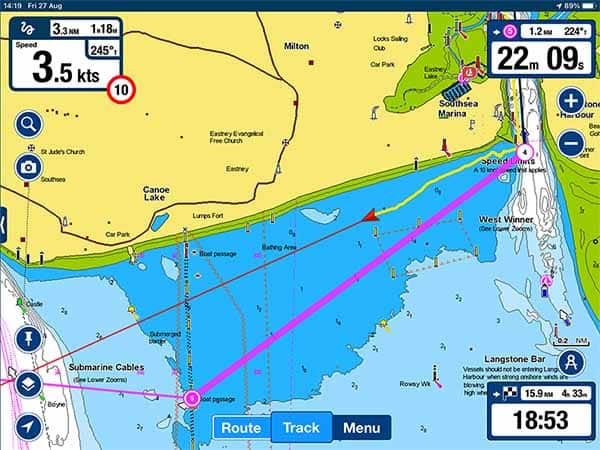
Once connected, the navigation display is great and easy to use.
Your own vessel is displayed clearly as a red triangle, with a vector indicating your course and speed.
The leg of the route that you are currently following is highlighted so that you can easily see the path you are aiming for.
Around the edge of the screen, you have a fantastic display of the most relevant data for recreational boaters.
Your course and speed are clearly shown in the top left, along with an indication of the speed limit if applicable.
In the top right, Navionics shows you information about the leg of the route that you are currently following.
In the bottom right, you have data about your overall route. You can immediately see your distance and time remaining, along with an estimated time of arrival.
Across the chart, you will notice that tide and current information is included as standard.
Arrows on the chart indicate the currents. You can interrogate each arrow to be able to pan forward in time to see what the current will be doing when you arrive.
Elsewhere, you will find tidal gauges, which can be interrogated in the same way. These give you the height of tide as well as telling you whether it is flooding or ebbing.
Overall, I found the navigation screen on Navionics was the best out of all the apps that I tested. I loved the data that was immediately accessible as I never needed to open other menus to see what I wanted.
The inclusion of tidal data was brilliant. I didn’t purchase extra tide information in any of the apps that I tested, but having it included as standard in Navionics was great.
Navionics & NMEA
Navionics can connect to your NMEA 0183 or NMEA 2000 network through your boat’s NMEA to WiFi gateway.
I was unable to test this feature fully as I do not have any other electronic equipment on my boat.
The WiFi connection seems easy and straightforward and will provide a feed of your navigational data, as well as an AIS input so that you can see other vessels.
Navionics will only display that data that is already displayed on your navigational screen, however.
For example, even if wind data is being fed through your NMEA network, Navionics is unable to display it.
Navionics will draw on the data that it needs, but it cannot be used as a full solution for a portable NMEA interface.
Usability
I found that Navionics was easy to use and very intuitive. Wherever extra explanations were needed, the app included them.
It is clear that Navionics has been well designed, and refined for use by recreational boaters.
The chart displays information well, and the screen does not become too cluttered, compensating for the lack of chart layer controls.
Passage planning is simple, with enough options for most users.
Overall, I found that Navionics was one of the most user-friendly navigation apps that I tested.
My Verdict
Navionics is a great marine chart plotting app, and it is clear to see why it has become so popular.
It follows a simple and very reasonable pricing model, meaning that I could use all of its functions for £34.99 ($35.99) across the entire UK, Ireland and Holland.
The only downside is that Navionics is very much a “plug-and-play” solution, meaning that it has fewer customisation features than some of the other apps I tested. A lot of users will, however, see this as a positive.
I would recommend Navionics for any recreational user who just wants a reasonably priced app that will work and will be easy to use. Navionics does everything that most recreational boaters need, and it does it well.
Frequently Asked Questions
Does Navionics work without internet?
Navionics only needs to access the internet for downloading the app, downloading charts & updates, and for synchronising with your account. Once you have charts downloaded to your device, Navionics will work offline.
Can you install Navionics on a laptop?
The Navionics Boating App is only available on Apple and Android devices.
For users wanting to access the Navionics App on a laptop, you can use the Navionics web app instead: https://webapp.navionics.com
When you log in to your Navionics account, routes that you make in the web app will synchronise across all your devices so you can access them from your phone or tablet.
Does Navionics use GPS?
The Navionics Boating App uses GPS to plot your position on the chart.
With devices that have an integrated GPS, Navionics will use that. Alternatively, you can use a Bluetooth GPS, or connect to your boat’s NMEA network through WiFi.