Seapilot: Reviewed By A Professional Navigator
With more and more boating enthusiasts beginning to use their phones or a tablet for marine navigation, I wanted to try it out as well.
I recently went sailing on my own boat, so checked out the app stores to get myself an app.
With so many to choose from, I decided to buy a few different ones so that I could independently test and compare them all.
One of the apps I purchased was Seapilot, from Raymarine.
Seapilot is a capable marine navigation app that is incredibly easy to use. Using vector charts, you can automatically plot your boat’s position from your mobile’s GPS or even integrate with your boat’s GPS through a NMEA to WiFi interface.
| Positives | Negatives |
|---|---|
| Charts are cross-platform | Premium needed in most cases |
| NMEA integration | Limited data on the navigation screen |
| Chart looks great | |
| Clear image of own vessel’s position |


The first thing to note with Seapilot is that they offer a Free version or a Premium version. For most useful functions, you will need a Premium subscription which costs £29.99 ($39.99 USD).
The premium subscription does allows your charts to be used across multiple platforms, so I could use the same ones on my iPad and on my Android phone.
When I first started using Seapilot, I was pleasantly surprised by the professional feel of the charts in use. They felt very familiar compared to the commercial standard charts I am accustomed to from navigating large ships.
Scrolling around the chart was fast and seamless.
Passage planning was simple, and very well thought out by the app’s designers.
When you place waypoints, the point is offset from your finger position so that you can see exactly where it will be dropped on the chart. I didn’t notice this feature on any of the other apps that I tested.
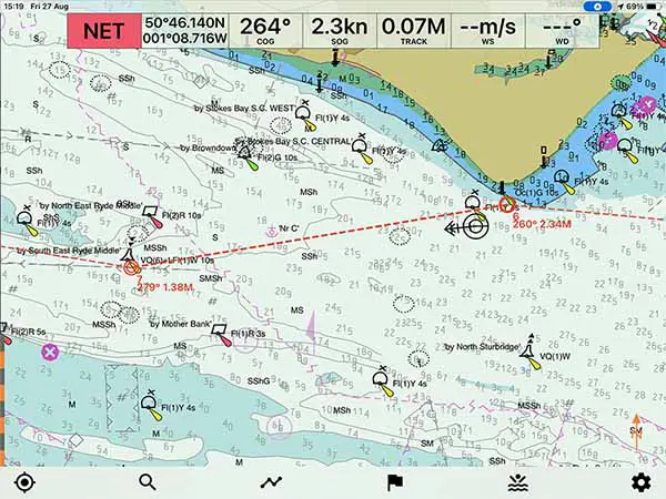
In navigation mode, Seapilot clearly presented the chart information and clearly overlaid my own boat’s position.
Data like COG and SOG was clearly visible at the top of the screen, however, to get additional data like DTG and TTG to the end of my route, I needed to pull up the additional “Routes” page.
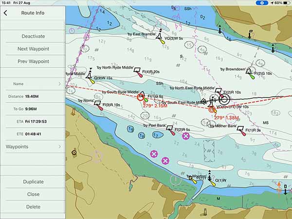
Unfortunately, once the “Routes” menu is open, you lose your COG and SOG, so there is no way of displaying everything at once.
Aside from the data on display, Seapilot was one of my favourite apps from the test that I undertook.
I would be happy to continue running Seapilot on my own iPad in the future.
If you are considering purchasing Seapilot, you should first read this article where I compared the 8 different navigational apps that I used during my sailing trip: Top 8 Apps For Marine Navigation (Judged By A Navigator).
Seapilot pricing
Like most other navigational apps, you can download Seapilot for free from the App Store or Google Play.
The free version comes with basic functions, as listed in the table below:
| Free | Premium |
|---|---|
| Fully functional navigation app | Everything in “Free” |
| Own position | Past tracks |
| MOB | Routes & waypoints |
| Marks | Weather routing |
| Search chart location | GRIB data & presentation |
| Head up / North up | NMEA inputs |
| Chart updates per cell | GPX import / export |
| Social boating | Weather forecast |
| Internet AIS | |
| Multi device | |
| Auto route | |
| CPA |
As you can see, for most people you will need to upgrade to the Premium app to be able to do basic navigation like preparing routes and tracks or viewing your own past tracks.
Premium costs £29.99 ($39.99 USD).
Once you have the app that you want, you also need to purchase and download the charts that you need.
US charts are available for free, but other countries will incur a charge.
I needed a pack of Great Britain charts, which cost me £17.49 ($25).
Interestingly, with Premium, you get to use the charts on multiple devices. I can use the same charts on my Android smartphone as well as my iPad.
When you check the in-app stores, however, the charts cost a different amount for each device. It is worth checking both devices because you may find it cheaper in one compared to the other.
Given you can use the same charts across both devices, you may as well buy the cheaper charts.
For my test, in total, I spent £47.48 ($65) on Seapilot.
What charts does Seapilot use?
Seapilot uses vector charts based on data from national hydrographic organisations.
As it uses vector charts, you do have some customisation available so that you can select which layers to display.
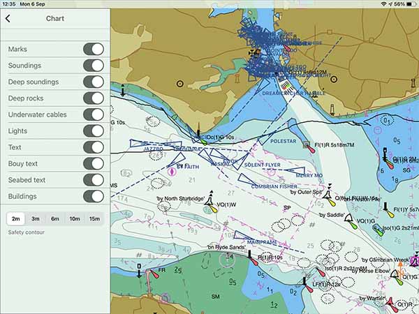
You do not get as much control as you do in some other apps, but I found that the control available was plenty for my needs.
Generally, with chart layers, you should always navigate with as many layers active as possible. You only turn off a layer when the chart gets so cluttered that you cannot safely navigate with it.
During my testing, I never found the chart too cluttered, even with all layers active. Therefore, I am happy to state that there was plenty of customisation for my needs.
Downloading charts with Seapilot
When you purchase charts in the Seapilot in-app store, you get the option to “Install” them to your device.
Installing them will download the entire file and load it onto your device.
It is safe to assume that if you can see a chart on your screen, it has been downloaded and will work offline.
You might see this as a positive because you know that you will always have access to the entire chart that you have purchased.
It is worth considering, however, that if you are navigating between regions then you may end up taking up a lot of memory with your downloads.
Passage planning with Seapilot
I found that passage planning within Seapilot was easy and intuitive.
With the chart open, you just do a long tap on the chart to bring up the cursor menu.
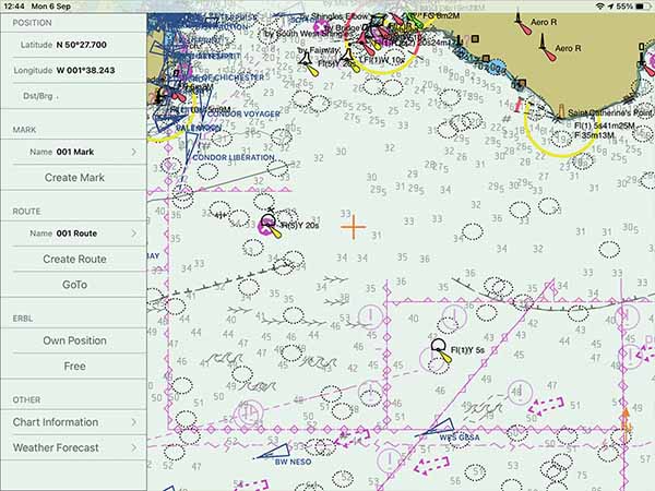
From there, you can select “Create Route” to place your first waypoint, conveniently labelled “Start”.
From there, every time you do a long press on the screen you will place another waypoint which you can move around as required.
Seapilot makes it very easy to place waypoints accurately because the point offsets from where you tap so that you can see it clearly. With most other apps, the waypoint stays beneath your finger so it is hard to see.
Within the “Routes” menu, you can select any number of routes that you want to display, so it is easy to recreate one that you have previously made.
Overall, I was impressed with passage planning in Seapilot. It was less comprehensive than some other apps but was still able to do everything I needed it to do.
Navigating with Seapilot
When preparing to navigate with Seapilot, the main hindrance was my own iPad.
I own a WiFi-Only model, which does not come with an integrated GPS. I had to buy a Bluetooth GPS to be able to navigate. You can read my review of the one I purchased if you are interested: Garmin GLO 2 Review.
Once I got the GPS feed sorted, navigating on Seapilot was a great experience.
Setting your safety contour correctly makes the chart look clean as it omits “dangers” that are not hazardous to your own boat.
Your own boat is indicated by a clear black circle outline, with a vector indicating your course and speed.
At the top of the screen, you have a very obvious display showing your COG, SOG, as well as some information about your track.
I used the COG and SOG, but would have really liked some extra information about my route to be displayed. I had to frequently check the “Route Info” data to find the DTG and TTG on my route.
Overall, I was very happy with the navigation experience on Seapilot. The chart displayed well, and it was always clear where my boat was and in what direction I was heading.
Seapilot & NMEA
Seapilot contains the capability to integrate with your boat’s NMEA to WiFi network interface.
Note: NMEA is a premium feature.
Through NMEA, it can draw on AIS and GPS data, as well as depth data on some devices.
This means that when you use a WiFi-only iPad as I do, if you have NMEA inputs for position coming from your boat’s system, you will not need an extra GPS.
Usability
I found that Seapilot was easy and intuitive to use, and was overall one of my favourite apps.
The way that it displays the chart was very pleasing to use because it had a lot of data, but the shading used meant that it didn’t look too crowded.
Your own boat’s position and vector are displayed clearly so it is easy to use even when you are not holding your iPad.
I place mine in the companionway of my boat, and Seapilot remained clear and visible even when I was at the helm, a few meters away.
Passage planning was intuitive and easy so users who have never done passage planning on an electronic chart should be able to plan with minimal tuition.
My Verdict
I would recommend Seapilot for recreational users looking for a capable nautical chart app that is simple to operate.
It is not a “free” app because the features included for free are minimal. For almost every function, you will require a Premium subscription, so you should just assume that Premium is the base cost of the app.
The display of the chart is great, and the route planning functions are well thought out and easy to complete.
My main criticism is in the data that is displayed on the navigation page because I found myself frequently needing to open the route menu to check things like my ETA at my destination.
Frequently Asked Questions
Does Seapilot require an internet connection?
Seapilot requires an internet connection to download the app and charts and to make in-app purchases. Once your charts are downloaded to your device, Seapilot will work offline.