iNavX vs Navionics: An Ultimate Comparison
While reading online reviews, I constantly found references to iNavX. It often wins out against other applications, so I just had to try it out for myself.
Testing it on its own didn’t seem enough. I wanted to put it against one of its tougher competitors, Navionics.
The results were not what I expected.
iNavX is a more comprehensive and sophisticated app than Navionics, but it is less visually pleasing and seems a little less well refined. The additional features, while great on their own, do add significantly to the complexity of the app, giving it a very steep learning curve.
I found that with Navionics, I could open the app, and I was immediately able to do everything I wanted to.
Passage planning and navigation were both simple and intuitive.
With iNavX, I needed to consult the user manual on multiple occasions, simply because it does some things differently from any other app.
Nevertheless, there are undoubtedly more features available in iNavX, evident from their extensive NMEA interface and customisation options.
When you get used to those, iNavX will perform extremely competitively against any other navigation app.
With Navionics, however, what it lacks in customisation, it makes up for in refinement.
There was rarely an occasion when I wanted to change the way that Navionics does things by default.
As I am based in the UK, the price of the apps was considerably different due to the charts I needed to buy.
iNavX worked out as the most expensive app I tested, but users in the US may find they are able to navigate using free raster charts from NOAA instead.
The range of charts on offer was vastly different between the two apps. In their respective in-app stores, Navionics only sells Navionics+ charts, but iNavX sells Navionics+ charts as well as many others.
Overall though, between iNavX and Navionics, I would rather have Navionics.
I just found everything easier to use, and I found the app was more refined.
iNavX and Navionics are not your only options when choosing an app for marine navigation though. If you want a wider choice, you should check out this article I have written, where I compare lots of them: Top 8 Marine Navigation Apps.
What is iNavX?
iNavX is an extremely comprehensive and customisable marine charting application for iOS and Android devices.
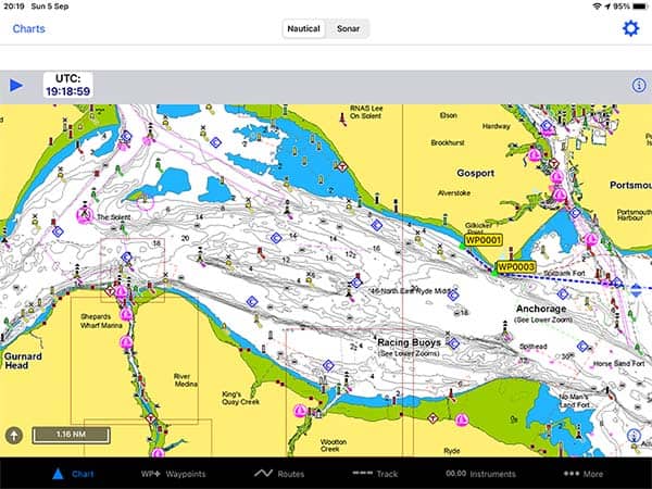
Out of all the apps that I tested, iNavX has the most potential for integration with your boat’s systems. Their NMEA interface is capable of displaying almost anything on the screen.
The screen itself is customisable, so you can select the data that you want to display in the bar along the top.
In terms of charts, unlike a lot of marine charting applications, iNavX does not produce any charts themselves. Instead, they offer charts from a whole range of providers directly in their in-app store.
In the US, there are free NOAA raster charts available for iNavX, but in other countries, you will need to purchase them instead.
This led to the biggest downside from my perspective. iNavX was the most expensive app out of all the navigation apps that I tested, by a considerable margin.
Passage planning was not as intuitive as other applications, either, but after reading the instruction manual I was able to do most of what I wanted to.
iNavX has more customisation and controls than most other chart applications, so once you get used to it, it is a very powerful and capable navigation system.
If you are considering iNavX for your own boat, you might be interested in my comprehensive review: iNavX: Reviewed By A Professional Navigator.
What is Navionics?
Navionics is a recreational maritime charting application produced by Garmin.
It is incredibly popular within the community, having topped several polls of the most popular charting applications.
The Navionics community is one of its greatest assets, giving a unique additional data source that is unmatched by its rivals.
Community edits on charts give you an extra level of local knowledge that just isn’t available elsewhere.
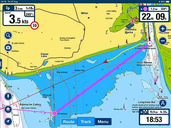
When the app is running, it is one of the easiest and most intuitive to use.
The chart itself is clear and easy to read, with lots of additional information placed around the edge of the screen.
It was immediately obvious that the app has been well designed and continuously refined by those that are actually using it.
Passage planning in Navionics is simple and intuitive. You simply tap along the chart in a line to create your route, and that is pretty much it.
The biggest downside that I found with Navionics was its simplicity. For most users, it might be considered a good thing, but I would have liked a little more control than I was actually given in terms of the chart and route customisation.
If you are considering purchasing Navionics, you might be interested in my full review: Navionics App: Reviewed By A Professional Navigator.
iNavX vs Navionics: Which wins on price?
Winner: Navionics
Navionics is available to download for free from both the App Store and the Play Store. Then, when you purchase a chart subscription, it activates all the advanced functionality on the app.
With iNavX, it is free to download from the Play Store but will cost £4.49 ($6) to download from the iOS App Store. Then, you can choose which charts to purchase.
To make the comparison fair, I decided to purchase the same charts for both apps, Navionics+.
Within the Navionics app, I selected the “UK, Ireland & Holland” pack for £34.99 ($35.99).
In iNavX, I purchased the “Navionics+ UK, Scotland, Ireland, Netherlands, Belgium, France N (iPad)” pack for £83.99 ($116).
Although both charts are created by Navionics, you cannot use the same subscription for both applications.
With the Navionics app, the same subscription applied across my Android phone and my iPad, so I could access both after purchasing.
With the iNavX app, the purchase only applied on the iPad, so I would have had to buy it again to use it on my phone. As I had already spent more on iNavX than any other app, I did not want to pay again to use it on a second device.
For my circumstances, Navionics was the clear winner in terms of price.
For users in the US, iNavX does include NOAA raster charts for free, so if you are happy using those, iNavX might win on price for you.
iNavX vs Navionics: Which one has the best charts?
Winner: iNavX
The Navionics app uses Navionics+ charts, available to purchase in its in-app store.
The iNavX app uses charts from a whole range of providers, one of which is Navionics+.
iNavX users can access charts and information from:
- Navionics+
- C-Map
- Canadian Hydrographic Service
- Blue Latitude Press
- Delius Klasing
- Explorer
- NOAA
- Waterway Guide
- Theyr
Given the huge selection on offer, iNavX is the clear winner in terms of charts.
iNavX vs Navionics: Which is best for passage planning?
Winner: Navionics
iNavX and Navionics adopt two different techniques for passage planning.
With Navionics, you tap along the screen to create a series of waypoints that join together to make a route.
It is very simple and intuitive, and I was able to complete my passage plans without consulting the app’s documentation.
With iNavX, passage planning is a little more complicated.
You first create all your waypoints, carefully labelling them as you go because you will need them in the next step.
Then, you go into the route planning menu and create a new route, selecting the waypoints you want from a list.
Once you have created the route from a series of waypoints, you can then amend it by dragging the points around your chart.
To complete my passage plan using iNavX, I needed to consult the app’s user manual because I couldn’t work out that it was impossible to create the route straight on the chart.
Overall, I found that passage planning in Navionics was simpler and easier than in iNavX.
iNavX would hold the advantage if I wanted to reuse lots of the waypoints again, but for the types of passages I was planning, Navionics was better.
iNavX vs Navionics: Which is best for navigation?
Winner: Navionics
Navionics and iNavX can each give a very different experience when used for navigation.
The overriding theme is that iNavX provides a much more customisable experience, allowing you to control everything, right the way down to the colours of your vectors.
Navionics gives a much more refined experience by default, with very little customisation in comparison.
The only thing you cannot control in iNavX is the location of the instrument displays around the edge of the screen. This is where Navionics starts to creep ahead.
By default, the navigation screen of Navionics has your course and speed in the top left. The top right has the course and speed to your next waypoint, and the bottom right has DTG and TTG on your overall passage.
The centre of the screen is left completely un-cluttered to maximise the view of the chart.
iNavX displays its data in a bar along the top of the screen. While you can customise the data that is displayed, you cannot move it away from the bar at the top of the screen.
Overall, although the navigation experience in iNavX is a lot more customisable than it is in Navionics, I felt like Navionics was so well designed that I had no need to customise it.
There will be plenty of people who do prefer the level of customisation offered by iNavX, but for me, Navionics was the winner.
iNavX vs Navionics: Which one is best?
Winner: Navionics
Given the choice between iNavX and Navionics, I would choose Navionics.
First and foremost, Navionics costs considerably less than iNavX for users that will not be using NOAA Raster Charts.
I found that iNavX was so expensive that I was not willing to test it on my phone as well as my iPad. With Navionics, use on both devices was included as standard.
Admittedly, iNavX does provide considerably more scope for customisation than Navionics does. With my experience, though, I found that I did not need to customise Navionics.
The main improvement that I would have liked in Navionics would be the ability to control the vector length.
Otherwise, the layout of the screen and the display of information had been so well designed that it did not need customising.
For passage planning, Navionics came out ahead of iNavX. iNavX just seems to perform passage planning in a different way to all the other apps that I tested, so it was hard to get used to.
I remembered the technique because I would do it on the old-style GPS systems where you would enter a series of waypoints to make a route. It just seemed odd that an app displaying a nautical chart would not let you tap on it to make a route.
Despite my conclusions, iNavX is still a very capable and comprehensive nautical chart application.
Especially for users with access to free charts, I would definitely recommend testing out iNavX.
Once you get used to the app, it will be able to do everything you want it to do.