iNavX: Reviewed By A Professional Navigator
On a recent sailing trip, I wanted to test if I could use my mobile phone or iPad as a chart plotter. I checked the different app stores and was immediately met with lots of different apps, all promising very similar results.
In the end, I purchased a few of them, with the intention of independently testing and comparing the most popular. One of the apps I tested was iNavX.
iNavX is a highly customisable maritime charting application, offering charts from multiple different providers. Its versatility is its greatest strength, but also its biggest weakness. It makes for a steep learning curve to use the app to its full potential.
| Positives | Negatives |
|---|---|
| Great selection of charts | Charts are not cross-device |
| Low cost in the US | Most expensive charting app that I tested |
| NMEA connectivity | Route creation was confusing |
| Extensive customisation | Steep learning curve |


iNavX is a very capable maritime navigational charting app, with a lot of sophisticated features.
As you would expect with such an extensive app, there is quite a steep learning curve to get the most out of the app. iNavX was actually the only app that I tested where I needed to consult the user guide on multiple occasions.
Users in the US will benefit from free NOAA charts, but users elsewhere will need to purchase packs of charts covering their location.
For the South Coast of the UK, I purchased Navionics charts within iNavX, making it the most expensive app that I tested.
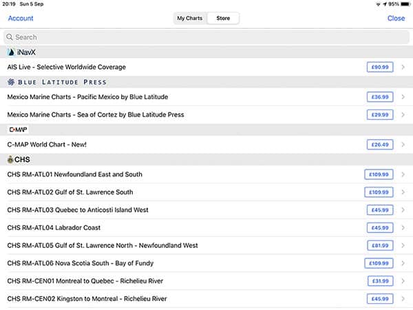
One great feature of iNavX, though, is that you have a choice of the charts that you can use. Their in-app store contains options from a number of different chart providers.
The app fully integrates with NMEA 0183 and NMEA 2000 through a WiFi interface from your boat’s network. Once connected, you can display any of the data feeds right on your navigation screen.
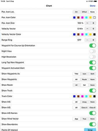
An extensive menu gives you full customisation over the data display on your main chart display.
If you are considering purchasing iNavX, you might be interested in reading this article where I compared 8 different navigational apps that I used during my sailing trip: Top 8 Apps For Marine Navigation (Judged By A Navigator).
iNavX pricing
iNavX was the most expensive app on my test by a considerable margin.
On Android, the app itself was free to download, then I would need to purchase the chart package that I wanted.
In my case, the UK charts for my passage would cost me £53.99 ($75) for a 1-year subscription on “Android Smartphones”.
On my iPad, the app itself cost me £4.49 ($6) to download, then I needed to purchase the chart package on top of that.
I selected the “Navionics+ UK, Scotland, Ireland, Netherlands, Belgium, France N (iPad)” pack for £83.99 ($116), taking my total spend for the iPad app to nearly £90 ($125).
For users in the US, iNavX includes free access to NOAA US charts.
Frustratingly, the charts that you purchase are not interchangeable between devices, so I would need to purchase them all a second time to test them on my phone.
As I had already spent more on iNavX than any other app, I decided to continue my test only on the iPad version.
What charts does iNavX use?
One of the best selling points about iNavX is that you can use charts and information from lots of different providers.
- Navionics+
- C-Map
- Canadian Hydrographic Service
- Blue Latitude Press
- Delius Klasing
- Explorer
- NOAA
- Waterway Guide
- Theyr
All the different charts are available to purchase from the in-app store for varying prices.
As you get such a selection, iNavX can be a great choice if you are going to be cruising between areas covered by different providers.
There are raster and vector charts in the store, so you can usually pick whichever you prefer, depending on your location.
Vector charts come with some customisation of layers, however not as much as you would expect considering how customisable the rest of the app is.
I downloaded the Navionics+ set for the iPad, which is actually different to the Navionics+ set for Android Smartphones. Assuming the same applies to other chart sets, you will need to purchase multiple copies of the same charts to use them on different devices.
Interestingly, I was also testing the Navionics app with Navionics charts, but I found that the charts were not transferable. If you use Navionics charts elsewhere, you will need to purchase them again to use them in iNavX.
Downloading charts with iNavX
Downloading charts with iNavX is simple and easy.
From the in-app store, you just select the charts that you want and press “Download”. The app then downloads the entire set that you selected.
Other apps only download the cells that you need, so depending on how you look at it, iNavX could be better or it could be worse.
On the positive side, you will know that the entire pack is downloaded, so you will never run off the edge of your charts.
On the negative side, if you are limited on space then your device may quickly fill up with charts covering beyond your intended cruising area.
Passage planning with iNavX
Passage planning with iNavX was not as intuitive as it is with other apps, and it was an overall very frustrating process. I had to read the user manual multiple times to work out how to do it.
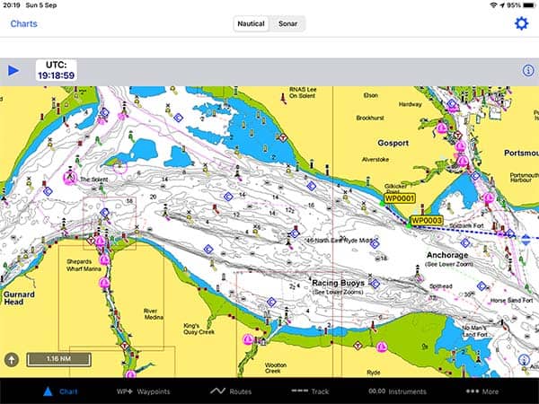
The menu at the bottom of the screen lists “Chart”, “Waypoints”, “Routes”, Track”, “Instruments” and “More”.
To create a route, you actually first need to create your waypoints. Waypoints are quite hard to create, and again I needed to consult the user guide to work out how.
When I was creating my waypoints, the chart kept jumping back to my home location, so I was frequently scrolling across the entire chart to get to the area in which I was trying to plan my passage.
While writing this review, however, I have been reading the documentation and discovered that you can disable automatic chart centering toggling “Pos. Icon. Loc.” in the settings menu.
As with most things with iNavX, once you discover their way of doing things it can work well.
With you have your waypoints set, you can create a route by going into the “Routes” menu and selecting “+” to make a new route.
You then select from your list of waypoints to join them together in a route.
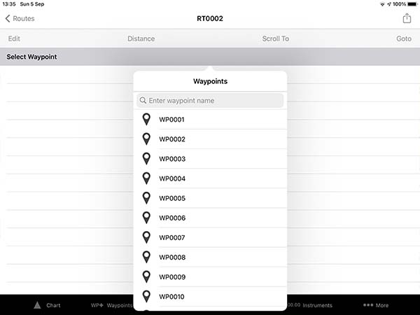
It was the only app where I could not create a route by simply tapping and dragging around the chart.
Once you have created your route, however, you can drag the waypoints around the chart if you prefer to amend your route that way. It’s just a shame that you cannot create the route in that way from the beginning.
My overall verdict about passage planning with iNavX was that it is OK if you will be frequently sailing to pre-determined waypoints (racing round marks for example), but it is not so good for cruising in different areas.
Out of every nautical charting app that I tested, route planning on iNavX was the hardest.
Navigating with iNavX
For navigating with iNavX, you just need a GPS input from your mobile device or iPad.
Users with a Wi-Fi-only iPad will find that there is no GPS, so you will need an external GPS instead. I used a Garmin GLO 2, and you can read my full review of it here: Garmin GLO 2 Review.
Alternatively, you can connect iNavX to your boat’s NMEA Wi-Fi for positional data, as well as pretty much any other data your NMEA network is carrying.
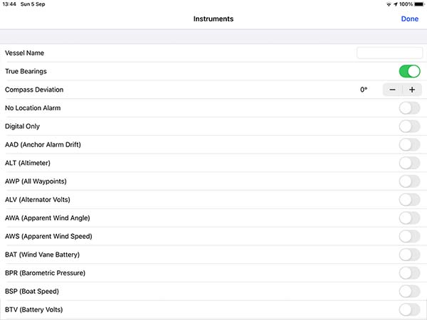
With iNavX, you have full customisation of the instruments displayed along the top bar of the navigation screen.
Personally, I only like to see my COG, SOG and distance and time to my destination. It was really nice to be able to select only the data I needed.
For your vessel display on the chart, there is great customisation available within the settings menu.
You can change its size and colour, as well as the size and colour of your vector.
Overall, with iNavX, the overriding feeling is that there is an incredible amount of customisation available with the navigation screens.
For users that become intimately familiar with the app, this is going to be a huge advantage. Unfortunately for me, I wasn’t able to get the full benefit of it because I was using so many navigation apps at once.
iNavX & NMEA
iNavX comes will full integration for NMEA over WiFi.
The data in the table below is from the iNavX user manual but this is not a complete list of all the NMEA integrations that iNavX is capable of.
| Altimeter | Alternator Voltage | Apparent Wind Angle |
| Apparent Wind Speed | Boat Speed | Battery Voltage |
| Course Over Ground | Depth Below Transducer | Engine Temperature |
| Position Type | Fluid Capacity | Fluid Level |
| Fuel Rate | Satellites In View | Magnetic Heading |
| True Heading | HDOP | Position |
| Oil Temperature | Oil Pressure | RPM |
| Speed Over Ground | System Time | Water Temperature |
| Air Temperature | Transmission Gear | Transmission Temperature |
| Transmission Pressure | True Wind Angle | True Wind Speed |
Overall, for NMEA compatibility, iNavX is one of the most extensive out of all the apps that I tested.
Usability
There is a steep learning curve with iNavX. Out of all the apps that I tested, iNavX was the only one where I had to frequently read the instruction manual to work out how to do the basics.
It almost felt like the app has been designed with so many customisations and options that it makes doing the basics too hard.
I was surprised because I hold type-specific ratings for a number of different commercial ECDIS systems, yet I was unable to use this iPad app without resorting to its manual.
With enough time, however, you would get used to the app and then it would be useful to have so much control over how everything looks.
Once you get everything set how you like it, iNavX does provide a good user experience.
My Verdict
I would recommend iNavX to users in the United States who like to have plenty of customisations available and are willing to put in the time to get the most out of the app.
For users elsewhere, however, you will probably be expecting more for your money after spending so much on the in-app chart packs.
For route creation, if you like to tap on the chart to create a route consisting of multiple waypoints, you will probably find iNavX just as frustrating to use as I did.
It is great for transferring the latitude and longitude from a paper passage plan onto your mobile device, but not so good for completing the plan from scratch.
If you are considering purchasing iNavX, I would first recommend you read my full comparison of all the apps I tested: Top 8 Apps For Marine Navigation (Judged By A Navigator).
Frequently Asked Questions
Can you use your Navionics charts on iNavX?
Within iNavX, you can purchase Navionics charts. If you already own a Navionics license, however, you cannot open your existing charts within the iNavX app. You will need to buy a second set of charts.
Does iNavX work without WiFi?
You need an internet connection to download the app and to download the charts. Once everything is downloaded onto your device, you do not need an internet connection to use iNavX.
Is iNavX the same as Navionics?
iNavX and Navionics are both maritime navigational charting applications. The Navionics app uses Navionics charts. The iNavX app can use charts from lots of different providers, one of which is Navionics.
In other words, iNavX and Navionics are different apps, but both are able to run Navionics charts.