NavLink: Reviewed By A Professional Navigator
On a recent sailing trip, I decided that I wanted to use my iPad to assist with navigation. To do that, I needed to find and download an app.
As it turns out, there are lots of apps capable of turning your tablet into a chart plotter. Instead of choosing just one, I bought all of them so that I could independently test them out, and compare them to find the best.
One of the apps I tested was NavLink, by Digital Yacht.
NavLink is an affordable app that turns your iPad or iPhone into a chart plotter, complete with customisable vector charts. Using Digital Yacht’s NMEA to WiFi connection, it can integrate with your boat’s GPS and AIS systems to create a complete navigational solution.
| Positives | Negatives |
|---|---|
| Integrates with Digital Yacht NMEA to WiFi connections | Not available on Android |
| Excellent price | Charts are slow to load |
| Simple route planning | Confusing selection of apps |
| Innovative features like Augmented Reality | Own vessel is hard to see |
| Automatic downloading of relevant charts | Navigational data is small |

For anyone familiar with SeaNav, NavLink looks and feels almost identical. The main difference between the two is that NavLink, by Digital Yacht, includes the capability of linking to your boat’s NMEA network through Digital Yacht’s NMEA to WiFi connection.
This is a great option and would be a deal-breaker if you were trying to choose between the two.
The NavLink app is intuitive to use, meaning that I did not need to consult the instruction manual while planning my passage or using it while navigating.
The charts are clear and easy to understand, with plenty of layer customisations available so that you can de-clutter your display when needed.
While planning, the app downloaded all the chart cells that I was using, so everything I needed for offline use was already on my iPad.
When changing the scale or location on the chart, there were noticeable delays in the loading at times. In fact, out of all the apps I tested, NavLink was the slowest for loading charts by a considerable margin.
Navigating was easy while I was holding my iPad, but I found my boat shape was small with little contrast compared to the underlying chart. Coupled with the small text size of the navigational data in sailing mode, it is quite hard to use NavLink when you are not physically holding your iPad.
In terms of price, NavLink is very competitive and significantly better value than some other apps on the test, especially when you consider its NMEA functionality.
Overall, I was happy with NavLink and able to do everything I needed to. I would definitely recommend it for users in certain situations.
If you place your iPad any distance away from you, however, or are frustrated by small delays in chart loading, this probably isn’t the app for you.
If you are considering downloading Navlink, you should first read this article where I compare the 8 different charting apps that I tested on my sailing trip: Top 8 Apps For Marine Navigation (Judged By A Navigator).
NavLink pricing
Confusingly, NavLink actually offers three different apps in the App Store. NavLink HD, NavLink UK and NavLink US.
NavLink HD is free to download, then you can purchase different chart subscriptions from the in-app store or upgrade to include “Pro Features”.
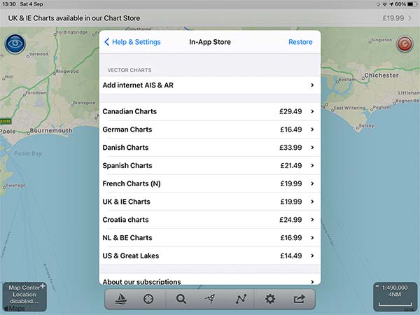
NavLink UK costs £30.99 ($43) and comes with a complete set of UK charts, and the potential to purchase additional charts covering European locations through its in-app store.
NavLink US costs £26.99 ($37) and comes with a full set of US charts.
Before my trip, I purchased NavLink UK, but now that I am writing up my review I notice that I could have got NavLink HD for free, then added UK charts for £19.99.
Instead, for £30.99 I purchased UK charts and Pro Features, even though I did not actually need Pro Features.
Pro Features includes Augmented Reality, as well as internet AIS capabilities.
Overall though, despite my confusion between the different apps on offer, NavLink’s pricing is one of the lowest among the apps I tested, even counting for my accidental purchase of extra features.
What charts does NavLink use?
NavLink uses vector charts, based on the data from the respective national hydrographic organisations for the areas the charts cover.
As the charts are vector-based, you get a great deal of customisation to get the screen looking how you want.
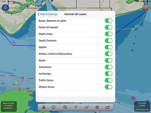
Pro Tip: Always navigate with all layers turned on, and only deselect layers if absolutely necessary due to screen clutter.
I find that the way NavLink displays data is both easy to understand and visually clear.
Downloading charts with NavLink
Downloading charts is very straightforward. NavLink seems to download charts as you are looking at them.
When I was completing my passage plan, at home on WiFi, NavLink was downloading the charts as I was using them.
This meant that when I was on my boat, with no internet connection, all the charts that I needed were already downloaded.
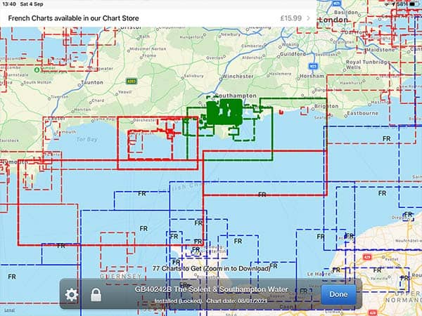
To be certain, you can go into the chart management option and see which charts are already downloaded to your device. The image above clearly shows the areas that I downloaded with a green highlight.
If you will be visiting other areas, you can either view them to download automatically, or just select them from the chart management menu.
Passage planning with NavLink
Passage planning with NavLink is intuitive and quick to complete. I was able to do all my passage planning without consulting the app’s documentation.
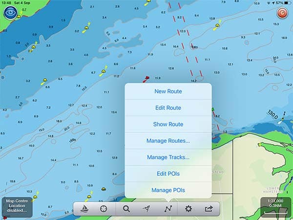
Entering the menu, you simply tap on “New Route” and are taken to the chart where you get told to “Tap and Hold on the Map to drop Waypoints for your route.”
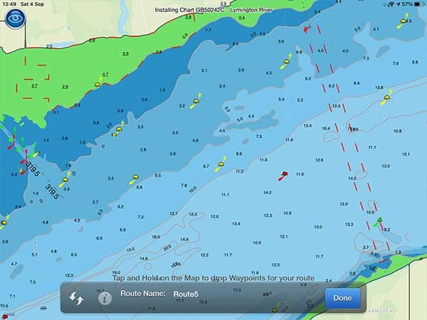
From there, it is intuitive to just drop all the waypoints along your route or long-tap on any to pick it up and move it to where you need.
Once your route is created, you can go back into the Routes & Tracks menu at any time to “Manage Routes…” and see all of the routes you have made previously.
Navigating with NavLink
To enter navigation mode, you just click on the image of a sailing boat. If you are not currently using GPS, the app will prompt you to turn it on before you enter sailing mode.
This is where I initially struggled with my app. I have a WiFi-only iPad, which does not come with GPS. I quickly purchased a Garmin GLO 2 Bluetooth GPS so that I could get it to work.
Read my full review of my GPS here: Garmin GLO 2 Review.
Reading through the NavLink documentation now that I am writing this review, however, I notice that you can use Digital Yacht’s NMEA to WiFi interface to receive a GPS input from your boat’s equipment as well.
For this reason, I rate NavLink ahead of SeaNav, which looks and feels almost identical. Read my full review of SeaNav here if you are interested: SeaNav: Reviewed By A Professional Navigator.
Once you have your positional input working, you can navigate on your tablet just like you would on a chart plotter.
Unfortunately, this is where my main criticism of this app comes.
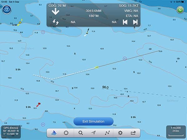
You can see that the image of your own boat is quite small, and lacks contrast in comparison to its background. This makes it quite hard to see unless you are physically holding your tablet.
I placed my tablet in the companionway of my boat so that I could concentrate on sailing from the helm. Even though I was only a meter or so away, I struggled to see my boat’s icon.
Similarly, the SOG, COG and waypoint information at the top of the screen was very small. I had to move from the tiller towards the iPad to be able to read the information that I needed.
The chart itself was great though, and I could easily see the buoys and hazards in my vicinity. All the icons were clear, and I could easily pull up any information I needed to find out what was around me.
NavLink & NMEA
On my boat, I only use a handheld VHF and paper charts, so unfortunately I do not have any other equipment to fully test the NMEA interconnectivity.
NavLink appears to be able to fully integrate with NMEA through WIFI though, which is a huge bonus for this app.
Using Digital Yacht’s NMEA to WiFI devices, you can connect your iPad to your boat’s data network.
NavLink then draws on both GPS and AIS data, giving you most of the information that you would expect from the most up-to-date commercial systems.
It can also draw on wind data through the same connection, displaying it on a separate screen within the app.
Again, I have been unable to actually test the NMEA interface myself, but reading that the app offers the functionality is a huge plus from my point of view.
Usability
I find that NavLink is both intuitive and easy to use.
I could complete all my passage planning and successfully navigate, without reading any of the documentation.
While using the app, everything is well explained so you can work out whatever you need as you go.
There are advanced features such as Augmented Reality that I played around with for a few minutes in trial mode, but didn’t actually use when I was out on the water.
With the charts, the only hindrance to usability is that they take a long time to load. Out of all the apps that I tested, NavLink had the slowest loading charts by a noticeable margin.
It made it quite hard to tell if the right data was being displayed as I scrolled in and out of the chart. Sometimes I would be waiting for soundings to appear at a certain scale, then they would never come.
Eventually, I realised that I needed to turn off SCAMIN to get the information I wanted at the scale I wanted. I would have reached that realisation a lot quicker had the charts been reliably loading quickly.
If NavLink was your only chart plotter though, you would quickly get used to the loading times and it would not hinder your safe navigation.
My Verdict
I would recommend NavLink as a great chart plotter app for anyone already using Digital Yacht’s products, depending on where you plan to mount your iPad.
The low cost of the app, paired with the NMEA integration means that it is one of the most cost-effective ways to get your boat’s data onto your iPad.
If you plan to mount your iPad next to your conning position, NavLink will do almost everything you need.
If you are like me, however, and you plan to mount the iPad at the other side of the cockpit and just glance up every now and then, you will struggle to read all the data that you want.
The low contrast and small size of the boat outline do make it hard to see from a distance. Similarly, the speed and course information in sailing mode is quite hard to see unless you are physically holding your tablet.
Users already familiar with vector charts will probably notice the slow loading of the charts in NavLink, but I found that after using it for a while I did adapt to it.
Especially as your first introduction to digital charts on an iPad, NavLink could be just what you are looking for.
Frequently Asked Questions
Does NavLink work offline?
You need an internet connection to download the app and to download the cells of charts that you need to use. Once they are downloaded, you can use the app as a chart plotter offline.
NavLink is one of the better apps for offline usage because it automatically downloads cells that you browse while you have an internet connection. This means that while planning your passage, the app downloads all the charts you need automatically.