iSailor: Reviewed By A Professional Navigator
With the advances in mobile and tablet technology, it is now possible for your devices to function just like a chart plotter.
On browsing the app store, I was met with a familiar-sounding name, Transas iSailor.
I was familiar with Transas (purchased by Wärtsilä in 2018) as a manufacturer of one of the most common commercial ECDIS systems, so I was intrigued about how it would perform on a personal mobile device.
iSailor is a commercial standard navigational system, adapted for recreational boaters on Apple and Android devices. It is intuitive and easy to use, yet still gives you a tremendous amount of control when passage planning or navigating. It was one of the best apps that I tested.
| Positives | Negatives |
|---|---|
| Excellent pricing | Not compatible with all devices |
| NMEA inputs | NMEA inputs require additional in-app purchases |
| Great passage planning features | Extra features (like tides) require in-app purchases |
| Great navigation screen | Advanced customisation not available |


iSailor is available for Apple and Android devices, however, it was not available on my Android Phone so you should check compatibility with all your devices before purchasing.
The app uses Transas vector charts, with worldwide coverage making it ideal for users navigating across different geographical areas. You just purchase and download the areas that you want to use.
For passage planning, iSailor was very easy to use once I worked out how to place waypoints. It also includes commercial features like XTD (cross-track-distance) as standard on all your legs.
You do not need to adjust it, but it is a great feature to have should you decide to use it.

In navigation mode, iSailor displays just the right amount of information, placing the correct amount of emphasis on data of most importance.
For example, SOG and COG are the largest font size, and your latitude and longitude are the smallest.
Customisation within iSailor is possible, however, a lot of control has been omitted.
It can be frustrating for advanced users, but for most people who are not familiar with different chart layers, SCAMIN etc. removing those controls is actually a much safer way of navigating.
It seems to me that iSailor has been designed by professional navigators, who want to bring the best parts of commercial navigation to the leisure market, while allowing it to be used safely by everyone, regardless of their level of training.
If you are thinking about purchasing iSailor, you should first consider reading this article where I compared the 8 different navigational apps that I used during my sailing trip: Top 8 Apps For Marine Navigation (Judged By A Navigator).
iSailor pricing
As with most of the chart plotter apps that I reviewed, iSailor is free to download, then you just purchase the charts and features that you require from the in-app store.
Individual charts are very reasonably priced. I paid £13.99 ($19) for a pack of “UK. England, South Coast” charts, which was all I needed for my trip.
With iSailor, US charts are not free, but they are available for a very low price. Most are priced at £2.79 ($4) for a whole pack from the in-app store.
To select the charts, the store contains a great world map, showing all the different regions where charts are available. You can click on any region and it will show you the charts available for that region.
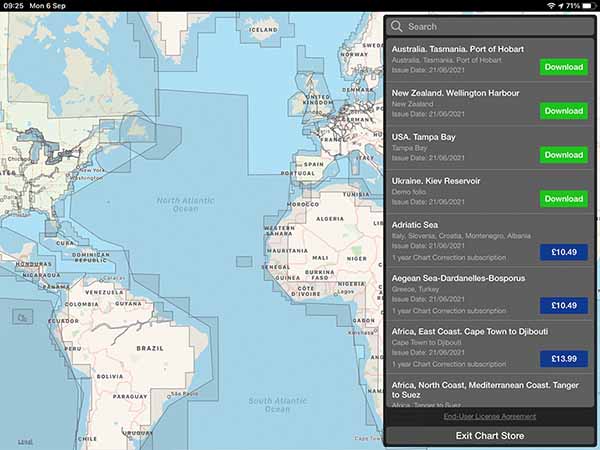
Alternatively, you can just browse through the list of available cells on the right-hand side of the screen.
Coverage seems great across most of the world, however, some of the ocean spots appear to be missing on the in-app map.
If that is the case for you, check their website because you may find that the chart is available, but not clickable on the map. This happened to me when browsing for “Atlantic Ocean. Offshore Waters”.
Aside from the charts, additional features also require in-app purchases.
For example, you need to make a purchase to be able to use NMEA connectivity or to get tidal information.
If you need a lot of features, iSailor could quickly become quite an expensive app.
My advice would be to download it for free, then add up the cost of every feature that you need before deciding whether you want to use iSailor.
What charts does iSailor use?
iSailor uses vector charts compiled using data from national hydrographic services around the world.
As the charts are vector-based, you can customise the display. iSailor does not allow much customisation, however, it was enough for what I wanted.
With chart customisation, the rule of thumb is to have as many layers turned on as possible, and only turn some off if they interfere with your safe navigation.
At no point did I find the screen too cluttered, so in that respect, there was plenty of customisation for what I needed.
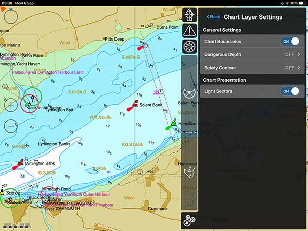
Setting the “Dangerous Depth” highlights soundings shallower than that depth in bright red. Similarly, the “Safety Contour” setting highlights the closest contour above the limit in bright red.
The other chart feature unavailable in iSailor is the ability to toggle SCAMIN. SCAMIN basically lets you display chart information at scales that it has not been designed for.
It is a safety feature that stops you from seeing buoys and soundings on a smaller scale than they were originally plotted for.
What this means is that you will see cells on your chart that contain less data than you expect. The data is still there, but you need to zoom in to the level it was designed for before you can see it.
Downloading charts with iSailor
Downloading charts with iSailor was simple and easy to do.
When in the store, you purchase the chart that you require, then just download and install the entire chart.
There are no additional steps to go through. Once the chart is installed, it is on your device and able to be used offline.
If you need to download charts for a lot of different areas, just be aware that they might quickly add up to a lot of storage space.
Passage planning with iSailor
Passage planning with iSailor was a little more complicated than other apps, but I was able to work it out after a few attempts without consulting the manual.
Clicking on “Create New Route” places a small flag on the screen. You can drag it around the chart as you wish.

You then press “+” to drop the waypoint. The current waypoint is still highlighted with the same information box, so you need to know at this point to tap somewhere else on the screen to set the second waypoint.
I kept pressing the tick instead and wondered why I could not set additional waypoints. A small hint on the screen would have been helpful here.
Intuitively, I thought the “+” meant “add a new waypoint” when it actually meant “add the current waypoint to the route”.
Once you do place your second waypoint, you get a range and bearing from your previous waypoint. I loved this feature. It is great to be able to place the next point accurately if you know you want a leg using a set range and bearing.
The next brilliant feature in passage planning with iSailor is that you can easily set a cross-track-distance (XTD), turn radius, and speed for each leg.
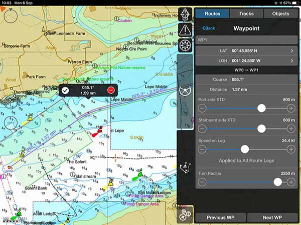
These are commercial standard features, so it was great to see them in this app aimed at leisure sailors as well.
Navigating with iSailor
Navigating with iSailor was great. So much so, that on the passages where iSailor was tested, I defaulted to it whenever I just needed to navigate without worrying about testing apps.
In the image above, you can clearly see navigation data on the right-hand side of the screen.
It was easy to bring it out and hide it again, however, I found it was quite unobtrusive so I kept it open the whole time.
By default, it shows your course and speed as dominant information. Then, further down you get information about XTD, course and distance to the next waypoint etc.
At the very bottom of the screen, you can choose which waypoint to reference, so you can set it to a particular waypoint or the end of your route. I found it incredibly useful if I wanted to pass a point at a particular time to catch the tide.
The only downside I found with navigation, was that it did not automatically do background recording of my track.
In the above image, you can see a gap in my track line where I was testing other apps.
As soon as I realised, it was a simple change to make so the rest of the passage was recorded correctly.
Your own boat shape is shown as a clear blue triangle with a vector indicating speed. I found it was easy to see on the chart at all times.
As with all the apps I tested, the main issue I found was with my iPad rather than the app. I have a Wi-Fi-only iPad which means I do not have an integrated GPS.
It was a simple fix, by buying an external Bluetooth GPS. You can read the full review of the GPS I purchased here: Garmin GLO 2 Review.
iSailor & NMEA
iSailor is compatible with NMEA, meaning that you can connect wirelessly to your boat’s NMEA to WiFi connection and bring the data in.
The main recommendation from me is to do it in advance because NMEA connection requires additional in-app purchases. You cannot do that unless you have an internet connection.

It is great to have the option to use NMEA inputs, however, just be aware that using any of them will require additional in-app purchases ranging from £4.49 ($6) to £8.99 ($12).
Please Note: The manual that is linked through the app is dated from 2015, so the most up-to-date NMEA connectivity instructions are not available in the manual.
Usability
I found iSailor to be both intuitive and easy to use. I did not need to consult the manual at any point while I was using the app for passage planning or navigation.
Information is displayed clearly on the screen, with a good amount of contrast on all the data.
It would require a little preparation if you wanted to use the app with your NMEA connections, however, simply because you need to purchase add-ons in advance.
Overall, I found that iSailor was very user friendly, but I would recommend that users not familiar with electronic charting techniques spend a little time practising to get the most out of all the features.
I acknowledge that I was already experienced with using XTDs before using the app, so if you have never met those before it may take a bit of practice.
My Verdict
I loved iSailor and would recommend its use for recreational boating.
Having in-app purchases for extra features is a little annoying, but users like me who do not need those features will find it incredibly well priced.
If you need all the extras, I strongly recommend you add up the cost of all features you need before committing to iSailor. You might then want to consider other apps which will be similarly priced when all that is taken into account.
With passage planning, it was simple and intuitive. Additional features like the XTD, turn radius and passage speed were great features to customise your plan exactly as you need.
Navigation mode was my favourite part. There was just the right amount of data available, all displayed in the correct way. SOG and COG are the most important, so they were rightly given the most space.
Latitude and longitude, while also important, are very rarely needed so it was great to see them written smaller and out of the way.
Overall, I was very happy with iSailor and would readily use it on my boat.
Frequently Asked Questions
What happens after my chart subscription ends?
Once your subscription ends, you will stop receiving updates for your charts. The charts you have previously purchased will still be available, but will no longer be the most up-to-date version.
Can you use iSailor without an internet connection?
You need an internet connection to download the app, purchase and download charts, or make in-app purchases. Once your charts are downloaded, you do not need an internet connection to use iSailor.