C-Map App: Reviewed By A Professional Navigator
On a recent sailing trip, I decided that I would like to test out how well mobile technology performs as an aid to navigation. Specifically, I was interested in using my iPad or mobile phone as a chart plotter.
Browsing on the different stores, one app stood out to me because I recognised it from navigating cruise ships, C-Map.
I immediately downloaded it as I just had to test it out to see how it would perform on a mobile device on a small boat. To cut a long story short, I was impressed.
C-Map is a marine charting app that turns your phone or tablet into a chart plotter. Using vector charts, its display is highly customisable and it integrates with your device’s GPS to provide a complete navigation solution. For such a feature-rich application, it is intuitively simple to use.
| Positives | Negatives |
|---|---|
| Professional quality vector charts | Navigational information on the screen is quite small |
| Free option available | No NMEA integration |
| Premium pricing is reasonable | |
| Easy and intuitive to use |


When I first downloaded C-Map, I had high expectations because I had previously used it on the professional integrated bridge systems of modern cruise ships.
The app started up, and intuitively I was able to pan around and seamlessly zoom in and out for the areas I wanted to see. The charts ran incredibly smoothly on my iPad Mini.
As it uses vector charts, you get functionality to turn different layers on and off, really customising your display however you like. On mine, all layers were turned on by default. As the screen was not cluttered, I didn’t need to change anything.
Planning my passage was incredibly simple too. The buttons are labelled clearly, and there are handy hints that pop up on the screen telling you to “Long press in the map to add a waypoint” etc.
I was able to do everything I needed without consulting the manual at all.
In navigation mode, all the information that I wanted was easy to find. Speed and course were displayed on the screen, along with my position and vector. My only criticism in that respect was that the numbers were a little small.
I left the iPad in the companionway so that I could see it from the helm. From a meter or so away, some of the numbers were hard to read.
It was easy to pull up more information though, which was nicely presented and easily accessible at the edge of the screen.
Overall, I was left with the impression that C-Map was incredibly well designed to meet the navigational needs of an app user. Not only that, but the app comes with a complete set of worldwide charts that you can access for free.
You only actually need to pay for the Premium features when you want to use C-Map for navigation. As such, it was one of the best apps I tested, and I would not hesitate to recommend it as a navigational aid for anyone wanting to try mobile navigation.
If you are considering downloading C-Map, you might be interested in this comparison where I compare 8 different charting apps that I tested on one sailing trip: Top 8 Apps For Marine Navigation (Judged By A Navigator).
C-Map pricing
C-Map offers two different pricing options, Free or Premium.
I was able to access premium on a 2-week free trial, but once the trial ends I have the option to purchase a 1-year subscription for £42.99 ($60).
There may be other optional extras, but I am only interested in the functions included with the Premium subscription.
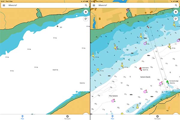
With the Free option, I could view worldwide nautical charts, plan passages and actually do everything that was needed before getting on board my boat.
The Premium subscription then offered the ability to download map tiles for offline use and the ability to use GPS functionality to actually navigate on the charts.
C-Map provides a full comparison table for Free vs Premium on their website. I have included the table below and highlighted the features that I actually used in bold.
| Free | Premium |
|---|---|
| View the latest nautical charts | Everything in Free |
| Manual & automatic routing | GPS position & full navigation |
| Add personal routes & record tracks | Unlimited offline maps (Global) |
| Add personal waypoints | 5-Day weather along the route |
| GPX import & export | 5-Day weather overlay |
| Thousands of points of interest | High-resolution bathymetry |
| Marine weather froecast | Custom depth shading |
| Weather along the route (24h) | AIS |
| Chart personalisation | C-Map traffic: View other app users |
| Measure distance tool | Shaded relief |
What charts does C-Map use?
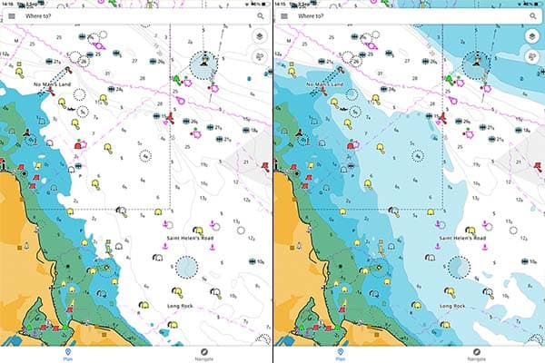
C-Map uses vector charts, making them highly customisable. This can be hugely advantageous when used correctly.
The image above contains two screenshots of the same location on the chart. On the left-hand side, I have turned off all of the charted features. On the right-hand side, I have turned everything on.
You can see how easily you could customise the chart to your liking if you find it too cluttered up with unnecessary data, however, you should always exercise caution because you could turn off important data.
Pro Tip: Always navigate with as many layers as possible, provided the screen does not become too cluttered for safe navigation.
The other great advantage of these charts is for contour customisation.
For example, my boat has a draft of 0.5m, so I consider any charted depth above 1m to be perfectly safe.
When I set the Depth Limit to 1m, the visualisation of the seabed changes entirely. It becomes much more obvious where it is safe to navigate.
Pro Tip: I do usually leave the Depth Limit set at 10m because it is nice to be able to see how the seabed is shallowing up and get more of a 3-dimensional visualisation.
Downloading charts with C-Map
One of my favourite features with C-Map is the ability to only download the area that you want.
Once you have subscribed to Premium, you can select “Download offline maps” from the main menu.
You can then select the are you want to download, and it will tell you how many tiles it will be (you have a 1000 tile allowance), as well as the file size.
This is a particularly useful feature if you have limited storage space in the device you are using.
Regardless of what you download, when you have an internet connection you have access to the complete set of worldwide charts.
I have really enjoyed browsing through exotic islands pretending that I am planning to sail there.
Passage planning with C-Map
Passage planning with C-Map is intuitive and well designed. You simply press “Plan” to bring up the planning menu.
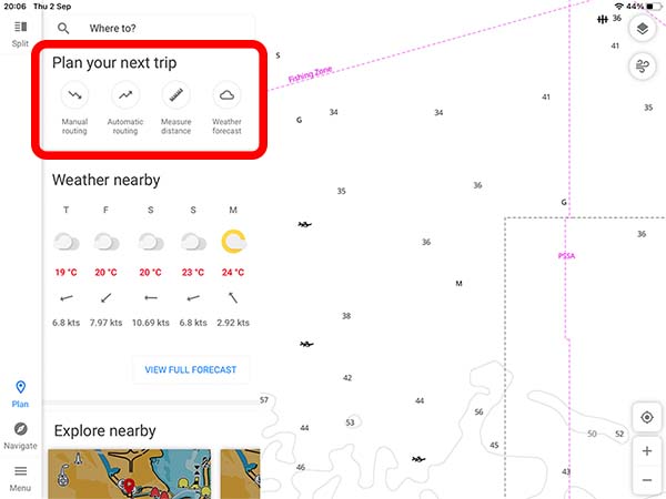
Once there, you have a choice between manual or automatic routing, as well as the ability to measure distances on the chart.
I used the manual option, which then just told me to “Long press in the map to add a waypoint”. Repeating that, I was able to add a series of waypoints and create a route.
I did try the automatic routing option as well. Although it appeared to make a safe track, the path it took seemed a little illogical. After that, I just stuck with the manual option.
Navigating with C-Map
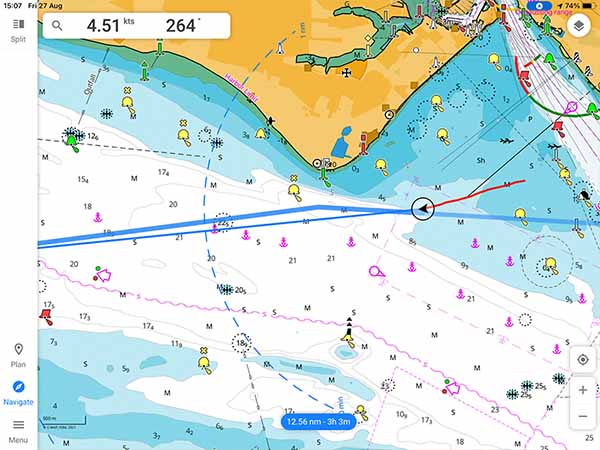
With the route planned, I was ready to navigate. It was a simple case of pressing “Navigate”, then “Start track”.
Your own vessel is presented as an arrow with its navigational line attached. By default, it plots a 1hr navigational line, but you can extend that to 12hr or 24hr instead if you want. I never changed mine from 1hr, because that was long enough to see the general direction I was heading in.
Behind your vessel, C-Map records the track that you have already navigated. By default, even when the app was closed it continued to track my position. I could return to C-Map after testing other apps and still see my entire passage.
Around the edge of the screen, you have numbers telling you your speed and course, and the overall route distance and time remaining.
My main criticism of C-Map is that I could not adjust the size of these numbers. I use an iPad Mini, and it was located a few meters from my position. It would have been nice to make the numbers larger to be able to read them clearly.
When I wanted to interrogate my navigational data further, I could pull up the navigation menu as well.
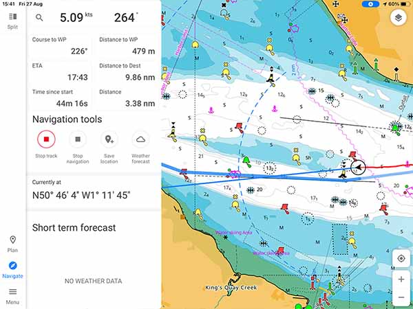
On this screen, I could find additional information about the course and distance to the next waypoint, as well as elapsed time and distance. It has been well thought out though, because that information is not actually needed a lot of the time, so keeping it separate worked well.
The main issue I had with navigating on C-Map was not actually to do with the app itself, but more to do with my iPad. I have a WiFi-only model, which does not have an integrated GPS.
In the end, I purchased a Bluetooth GPS to get the data I needed. If you want to find out about the GPS I bought, check out this article: Garmin GLO 2 Review.
I did not have any issues on my phone, where the integrated GPS seamlessly worked with C-Map.
Usability
I cannot find fault with the usability of the C-Map app. During my testing, I did not need to consult the user guide or look up anything I wanted to do.
Everything seemed intuitive, and simple to complete.
Assuming you already have some experience with vector charts, or chart plotters or similar technology, I do not think you will have an issue with the usability of C-Map.
There may well be features that I did not find or use, but for planning a passage on a small boat, I was able to find everything I needed.
Wherever I felt I might have struggled, small hints appeared on the screen telling me what to do.
It really felt like the app has been thoroughly tested by people that will actually be using it, rather than only software developers.
My Verdict
I really like C-Map for use as a full-featured navigational application on your phone or tablet.
It gives you most of the tools that professional vessels are using but packs it all down into a small app that you can carry in your pocket.
Particularly impressive is their pricing model. It is a unique feature to be given free access to worldwide charts for planning purposes. Their Premium subscription is also very reasonably priced, making them very competitive, especially if you frequently move between areas that would result in you buying multiple chart packs.
Overall, I would recommend C-Map as a great Chartplotter app for anyone on a small boat. You can try it out on the free version, then just upgrade to Premium when you decide you’d like to use it offline.
My only hesitation would come if you want to feed C-Map with data from your boat’s own navigational systems. I cannot find any mention of NMEA functionality and was not able to test that myself as I do not have any other fixed electronic navigation aids on my boat.
Frequently Asked Questions
Do you need an internet connection to use the C-Map app?
You need an internet connection to download the app and to use the free version looking at worldwide charts. When you are ready to go on passage, you can select the area of chart coverage that you require and download the relevant charts.
Once your charts are downloaded, you do not need an internet connection to navigate using the C-Map app.
Do I need a separate C-Map subscription for each device?
I used the same subscription for my phone and my iPad. I needed to log in to my account on both devices, then my premium trial was enabled on both.
Does C-Map integrate with my boat’s equipment?
I did not test C-Map with other navigational equipment as I was only testing the use of a tablet in isolation. I cannot find any reference to NMEA integration in C-Map documentation, so I believe it is only used as an app on its own.