Where Are The Highest Tides In The World?
The highest tides are spread throughout the world. They occur as a result of local geography creating a funnel to concentrate the tide from a large oceanic body of water. The top 5 highest tides in the world are:
| Location | Height (ft) | Height (m) | |
| 1 | Bay of Fundy, Nova Scotia | 38.4 | 11.7 |
| 2 | Ungava Bay, Quebec | 32.0 | 9.8 |
| 3 | Bristol Channel, UK | 31.5 | 9.6 |
| 4 | Cook Inlet, Alaska | 30.3 | 9.2 |
| 5 | Rio Gallegos, Argentina | 29.0 | 8.8 |
For the purposes of this article, we are referring to the greatest mean tidal range in the world. This means the difference in the height of the tide between low water and subsequent high water, averaged across all tides. The data we are using has come from NOAA: Tide Predictions And Data.
Top 5 highest tides in the world
No.1 Bay of Fundy, Nova Scotia 38.4 ft (11.7m)
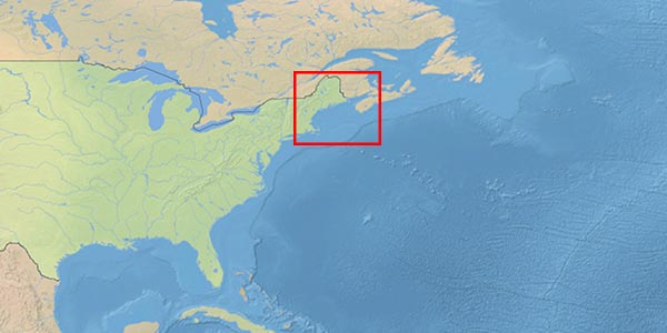
Burncoat Head, at the extreme North-Eastern part of the Bay of Fundy in Nova Scotia, records the highest mean tidal range in the world at 38.4ft (11.7m). The record for the highest single tide was actually set in 1869 during a tropical storm when the tide reached 70.9 ft (21.6m).
Tides are usually measured in multiple locations to give better, more local, information for mariners. Where the Bay of Fundy is identified as having the highest mean tidal range in the world, when you look at the individual stations it actually occupies the top six spots on the list.
| Burncoat Head, Minas Basin | 38.4 ft | 11.7 m |
| Horton Bluff, Minas Basin | 38.1 ft | 11.6 m |
| Amherst Point, Cumberland Basin | 35.6 ft | 10.9 m |
| Parrsboro, Minas Basin | 34.4 ft | 10.5 m |
| Hopewell Cape, Petitcodiac River | 33.2 ft | 10.1 m |
| Joggins | 33.2 ft | 10.1 m |
The geography of the bay creates ideal conditions for the highest tidal range. It is located at the North-Western corner of the North Atlantic Ocean. As the moon and sun pull on the ocean, it gets dragged towards the continent.
As the bulge of oceanic water approaches the continent, it encounters the Grand Banks. This is a large plateau that acts to increase the effect of the tide. Think about what happens with a tsunami. When it is out in the ocean you may not even feel it, but as it approaches the land it heaps up. The tides aren’t as pronounced as tsunamis because they effectively have a longer wavelength, but the principle is the same.
Finally, as the bulge reaches land, the shape of the coastline funnels the water towards the Bay of Fundy until it gets caught between Nova Scotia and the main continent. It is this effect of oceanic topography and coastal geography that causes the extreme tidal range in the Bay.
No.2 Ungava Bay, Quebec 32.0 ft (9.8m)
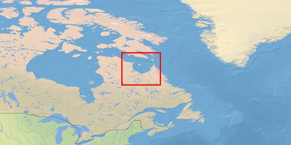
Leaf Lake in Ungava Bay, Quebec has the second-highest tidal range in the world at 32.0 ft (9.8m).
Ungava Bay is located at the confluence of the Labrador Sea, Baffin Bay and Hudson Bay. Interestingly, it is considered to be part of the Arctic Ocean as the 60°N parallel of latitude passes through the bay.
The shallow depth in the bay, combined with the funnelling effect of the geography is what causes the large tidal range.
No.3 Bristol Channel, United Kingdom 31.5 ft (9.6m)
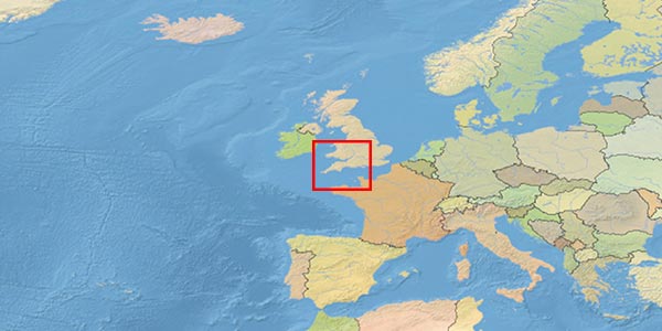
The port of Avonmouth in the Bristol Channel has the third-highest mean tidal range at 31.5 ft (9.6m).
The Bristol Channel is located at the mouth of the River Severn in the United Kingdom. It is at the North-Eastern corner of the Atlantic Ocean, connected via the Celtic Sea.
Just like with the Bay of Fundy, there are multiple locations within the Bristol Channel that feature of the list of the highest mean tidal range.
| Avonmouth, Bristol | 31.5 ft | 9.6 m |
| Newport, Wales | 30.3 ft | 9.2 m |
| Burnham, Parrett River | 29.9 ft | 9.1 m |
| Weston-super-Mare | 29.5 ft | 9.0 m |
Again, it is the geography of the area that gives the extreme tidal heights we see. The Atlantic water swells towards the United Kingdom, passing over the shallower continental shelf as it makes its way towards the land.
Unlike the English Channel further south, and the Irish Sea further North, when water enters the Bristol Channel it has nowhere else to escape. Water in the English Channel can pass through the Strait of Dover, into the North Sea. Water in the Irish Sea can pass all the way around the island of Ireland. In the Bristol Channel, the water heaps up instead, causing the highest tides in Europe.
No.4 Cook Inlet, Alaska 30.3 ft (9.2m)
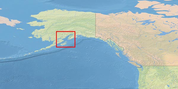
Sunrise, in the Cook Inlet in Alaska, has a mean tidal range of 30.3 ft (9.2m) placing it at the fourth spot on our list.
Sunrise is located in the North-Eastern corner of the Cook Inlet, at the inward end of the Turnagain Arm.
The Inlet itself experiences its tidal range because the local geography funnels the Pacific Ocean’s tidal bulge. Once inside the Inlet, the Turnagain Arm then funnels the water further creating the extreme tides at Sunrise.
The largest city in the area, Anchorage, Alaska features on the list with a mean tidal range of 26.2 ft (8.0m). It is slightly further out than Sunrise, so the funnelling effect of the Turnagain Arm doesn’t happen in Anchorage.
No.5 Rio Gallegos, Argentina 29.0 ft (8.8m)

Rio Gallegos in Argentina has the fifth highest mean tidal range in the world, at 29.0 ft (8.8m).
Rio Gallegos is located towards the southern end of the South American continent. It borders the western edge of the South Atlantic Ocean.
Just like the other places within our top 5, Rio Gallegos experiences its tide because of its local topography and geography. As the ocean bulge moves westwards, it hits the continent and is funnelled towards Rio Gallegos. Once in the river, the water has nowhere else to go so it causes the tide to rise significantly.
Slightly further south, the Strait of Magellan does not experience the same extremes of tidal height because it is open at both ends. As the tide rises on the Atlantic side, it can just flow through to the Pacific. At Rio Gallegos, when the tide rises in the Atlantic, it has nowhere to go so it presents itself as a higher tide.
What is the “mean tidal range”?
The mean tidal range is the average of all tides measured between low water and the subsequent high water.
During the normal lunar cycle, you get spring tides and neap tides. Spring tides are those that have the greatest range between high water and low water height. Neap tides are those with the smallest range between high water and low water height. The mean tidal range is just the average of all of these.
If you are in any of the areas we have listed, you will experience tides higher than indicated for half the lunar cycle. During spring tides you can expect all tides to be greater than those I have listed.
For example, the mean tidal range in Burncoat Head is 38.4 ft (11.7m), but the mean spring range is 47.5 ft (14.5m). Guinness World Records actually list the mean spring range as a record rather than the mean tidal range that I have used.
Can the tides be higher than predicted?
The tidal effects we have discussed are the mean tidal range, so all other effects have effectively been stripped away. On a day-to-day basis, however, tides will always vary from their predicted height.
Back in 1869 a tropical storm, Saxby Gale, struck the Bay of Fundy region causing the highest tide ever recorded. The tide that day was 70.9 ft (21.6m), which is significantly higher than the ranges predicted in any of the top 5 spots on this list. During that storm, a storm surge coincided with a perigean spring tide.
Day-to-day, normal atmospheric variations do also affect the tides. High pressure areas can depress the tide, and low pressure areas can raise the tide.
Similarly, wind also has an effect. Winds blowing in the direction of the tide will tend to raise it, and winds blowing against the tide will lower it.
In the 1869 storm, there was extreme low pressure from the storm combined with strong south-westerly winds and the perigean spring tide. All factors were acting to increase the level of the tide.
How are the highest tides measured?
Tides are measured using a tide gauge. Usually this is a graduated board that is mounted on a dock or other fixed structure. As the water level rises, you can read the height of the tide directly from the board.
Tide gauges are calibrated according to the datum in use at the port. In the past, ports would use local datums but now it is becoming more standardised. The most common measurement is to reference all tide heights to the Lowest Astronomical Tide (LAT). LAT is the lowest that the tide is expected to be due to gravitational effects.
Standardisation helps when using tidal measurements in conjunction with nautical charts. The common datum means that mariners can easily use the predicted height of the tide to estimate the depth of water that they will experience in a particular area.
Electronic tide gauges use the same principle as the boards in that they measure the height of water above the datum in use. The only difference is that they use electronic means to actually measure the water.
One of the more common methods now uses radar. A radar transmitter is mounted above the water to measure the distance to the surface. As the tide rises, the distance reduces. The major advantage of radar systems is that they can give a real time measurement electronically. When you check websites that tell you the current height of the tide, usually it is a radar that has given the measurement.
What influences the location of the highest tides?
The main influence for causing the highest tides in the world is the geography of the region. There will be a large body of water, like an ocean, for the sun and moon to pull on. High tide is caused when the water is pulled towards a land mass. Conversely, low tide is when the water is pulled away.
If there is a continental shelf extending out to sea, there will be an increase in the expected height of the tide. This is the same sort of effect that you see when a tsunami wave heaps up in shallow water. The only difference is that the tide is just one huge wave with a really long wavelength. It’s not a massive increase, but continental shelves do create a noticeable effect.
You find that the largest tides occur in locations that have a generally shallow body of water. When you try and pull an ocean across a shallow area, there will be a greater increase in tidal height.
The biggest increase is then found due to the local geography. If the land creates a funnel shape, it will act to funnel the large body of oceanic tidal water into a small area. The effect is then magnified as the funnel narrows towards one end.
When the land creates an open-ended funnel you don’t get the same effect. If there is a path for the water to escape through, it will just flow out the other end instead of causing a large tidal range. In this case, you would just end up with a fast current flowing through the narrow gap instead.
Where was the highest tide ever recorded?
The highest tide ever recorded was 70.9 ft (21.6m), in October 1869 at Burncoat Head, Bay of Fundy, Nova Scotia.
The record was a result of a combination of different forces. There was a perigean spring tide, which is the highest sort of spring tide that occurs during the normal tidal cycle. Perigean tides are those that result when the sun and moon are in line, and the moon is at its closest point to the Earth. The gravitational effects of the sun and the moon are at their greatest.
In addition to the high tide prediction, there was also a tropical revolving storm (TRS), the Saxby Gale. That TRS contributed a number of other factors that all acted to increase the height of the tide. This combination of factors is known as a “storm surge”, and is common with a TRS.
A TRS is an area of extremely low atmospheric pressure. When the atmospheric pressure decreases, there is less force pushing down on the water’s surface. Tides tend to increase when there is low atmospheric pressure. In a TRS, with extremely low atmospheric pressures, tides will tend to increase more than usual.
In addition to pressure, a TRS brings with it strong winds. When the wind blows towards the land, it acts to push more water towards the land, increasing the height of the tide. During the storm in 1869, the prevailing winds were lined up with the Bay of Fundy, funnelling more water up into the bay. Burncoat Head is at the inward end of the bay, so experienced the full funnelling effect of water flowing up the entire length of the Bay of Fundy.
Surprisingly, the rotation of the Earth also contributed to the extreme tide that night. The rotation of the earth causes the coriolis effect. This is the same effect that gives the TRS its direction of rotation. In the Bay of Fundy, the coriolis effect causes the tide to bend to the right as it hits the land. Effectively, the coriolis effect throws more water into the bay than you would otherwise expect.