What Is An EPIRB?
You may have seen them on boats, in aircraft, or even in hiking shops. Maybe you have purchased one yourself, or are considering buying one. Maybe you have never even heard of one before. So, let’s start at the beginning and ask: what is an EPIRB?
An EPIRB is an Emergency Position Indicating Radio Beacon. They are used to signal for help from any point on the surface of the earth. They transmit a 406 MHz signal to a network of satellites, which then relays your distress onto a rescue coordination centre.
It sounds simple enough, but in reality, an EPIRB is a highly complex piece of modern technology that has already saved countless lives.
The term “EPIRB” refers specifically to the maritime version of the small beacon that you can purchase.
All variants of that small beacon communicate with satellites within the COSPAS SARSAT constellation. In summary, they are designed to integrate with the GMDSS, or Global Maritime Distress and Safety System.
When activated, an EPIRB sends a distress signal on 406 MHz, up to the COSPAS SARSAT network of satellites orbiting the earth.
The satellites then relay your distress down to a rescue coordination centre, which can dispatch search and rescue assets to your location. Depending on your location you might see helicopters, ships, land vehicles or other emergency personnel sent to help.
An EPIRB can literally summon help to any point on the surface of the earth.
What types of EPIRB are there?
The term “EPIRB” is often used generically to describe any beacon that transmits a signal to the COSPAS SARSAT network of satellites that orbit the earth. In reality, however, the term “EPIRB” only describes the IMO approved maritime beacon. Beacons approved for other uses have a slightly different name.
EPIRB
Emergency Position Indicating Radio Beacons are approved by the International Maritime Organisation for use on different boats and seagoing vessels.
SEPIRB
Submarine Emergency Position Indicating Radio Beacons are a subset of EPIRB, designed for use on submarines. SEPIRBs are designed to withstand much greater pressures that are experienced on submarines under the water.
ELT
Emergency Locator Transmitters are designed for use on aircraft.
PLB
Personal Locator Beacons are designed for general outdoor use by individuals.
What do EPIRBs look like?
EPIRBs need to conform to International Maritime Organisation (IMO) performance standards. Specifically, EPIRBs need to conform to the standards within IMO Resolution MSC.471(101).
For approved EPIRBs, you can read Resolution MSC 471 Annex 24, which tells you all about performance standards of IMO approved EPIRBS.
In terms of their look, they need to be:
“Of highly visible yellow/orange colour and be fitted with retroreflecting material”
IMO Resolution MSC.471(101)
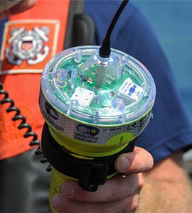
As you can see in the below image, EPIRBs all look broadly similar. They are a bright colour, in accordance with their performance standards. They also have a strip of retroreflective material which makes them immediately stand out when a light shines on them.
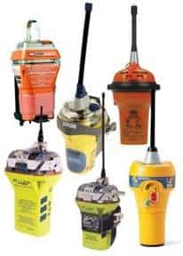
They are all fairly chunky, which is needed to provide the inherent buoyancy they need to have. The buoyancy needs to keep them afloat with their aerial in the air.
The intention of an EPIRB is that it will float on its own so that it can float free from a sinking ship, or you can tether it to a liferaft and leave it floating in the sea.
The aerial itself is another distinctive feature of an EPIRB. It sticks up in the air when the EPIRB is deployed to communicate with satellites. Most EPIRBs have a flexible black aerial permanently pointing upwards. Others will have a flexible strip that naturally unfurls when the EPIRB leaves its storage container.
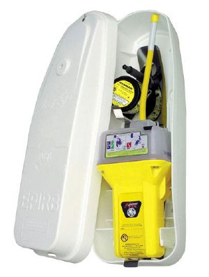
What do EPIRBs look like when stored?
When they are in their storage location, EPIRBs look different from the IMO definition that we described in the previous paragraph.

In their storage location, EPIRBs are stored in a float-free container. The container protects it from sunlight and weather so that the EPIRB can be kept in an exposed location.
They need to be stored in an exposed location so that they are clear of all obstructions so that they float free on their own should the vessel sink.
EPIRB storage containers have a hydrostatic release unit inside that will activate if it ever gets submerged. The idea is that should the vessel sink, the hydrostatic release will activate and cut the lid of the storage container free. Once the lid is released, the EPIRB can float away on its own.
You can read more about a hydrostatic release unit in this article: How Does A Hydrostatic Release Unit (HRU) Work?
What emergency situations are EPIRBs for?
We have discussed how EPIRBs are the maritime version of the emergency beacon designed to communicate with the COSPAS SARSAT network of satellites. As such, EPIRBs are designed for maritime emergencies.
Sinking
In a sinking situation, your vessel will no longer be available to signal the distress itself. The EPIRB is designed to operate independently from the vessel it is fitted to.
EPIRBs have their own independent power supply, aerial, GNSS receiver, transmitter and inherent buoyancy. They do not need any external inputs from the equipment of the ship they come from.
Even if you take no action when your vessel sinks, a Category 1 EPIRB will float free on its own and automatically summon help.
Fire
Fire is a very real danger on board ships and boats.
Unlike on land, in the event of a fire, there is nowhere to escape to. Your vessel is keeping you alive by keeping you afloat. If you needed to get away, your only option would be to jump into the water.
If you ever did need to jump into the water, grabbing an EPIRB on the way will alert rescue services to your location and increase the chances of a successful rescue.
Fire is only one consideration when planning where to mount your EPIRB. Read this article for a complete breakdown of all the considerations: Where Should You Mount An EPIRB On A Boat?
Capsize
When a vessel capsizes, it can lose all of its communication equipment because its aerials and masts will all be underwater. There is also a chance of crew members being trapped, either inside the upturned hull or on the outside, sitting on the keel.
In the event of a capsize, a properly mounted EPIRB will automatically activate and summon help.
Again, it is independent of all other equipment on your vessel. It does not matter that masts and aerials are underwater, the EPIRB has all of that built-in.
Should you find yourself trapped in the upturned hull, an automatically activating EPIRB can send a distress signal without needing any input from you as the operator.
The article below is just one of many cases where an EPIRB has been activated during a capsize situation, resulting in the rescue of the entire crew.
What industries use EPIRBs?
EPIRBs, or similar variants, are used by almost every industry that has anything to do with the maritime environment.
The more obvious one is the merchant marine industry. This comprises all ships internationally that transport passengers or cargo.
EPIRBs can signal for help from anywhere on the surface of the earth, which has driven the International Maritime Organisation to make them a compulsory part of a ship’s emergency equipment.
Generally, cargo ships carry at least one EPIRB, and passenger ships carry at least two. There are precise requirements in international conventions, so if you are interested in those I have covered it in depth in this article: How Many EPIRBs Are There On A Ship?
An extension of the merchant marine industry is the fishing industry. Again, the fact that EPIRBs signal for help from any location makes them an essential piece of emergency equipment for vessels in the fishing industry.
Although a lot of fishing vessels fall outside of SOLAS regulations because they are too small, most governments regulate them as commercial vessels anyway. Most will be required to carry an EPIRB to be deemed seaworthy.
The final category of vessels that carry EPIRBs are pleasure vessels. Most countries have no specific legal requirements for pleasure boats to carry EPIRBs, so it is usually up to the owner whether one is fitted or not.
In my experience, the main consideration by owners is not whether they have a beacon or not. Their main consideration is whether to carry an EPIRB or a PLB.
EPIRBs are specifically designed for the maritime environment, so they float and are assigned to an individual vessel. PLBs are designed for use by an individual, so you would carry it yourself.
PLBs are much smaller and have less strict requirements to comply with. As such, they are often cheaper than their EPIRB equivalent.
Read more: What Is The Difference Between An EPIRB And A PLB?
What are the different categories of maritime EPIRB?
EPIRBs are the maritime variant of the emergency beacon designed to communicate with the COSPAS SARSAT network of satellites. Within the specific category of “EPIRB”, however, there are two sub-categories.
EPIRBs fall into two categories: Category 1, and Category 2. Category 1 EPIRBs are designed to be fully compliant with SOLAS float-free requirements. Category 2 EPIRBs are the same beacon as Category 1 but are not capable of floating free on their own.
The beacon itself is identical. The only difference between the categories is in their storage.
What is a Category 1 EPIRB?
Category 1 EPIRBs are designed to float free when the vessel they are attached to becomes submerged.
They are mounted in a container that contains a hydrostatic release unit which activates when submerged to a depth of 1.5m – 4m.
When the hydrostatic release unit activates, it severs the mechanism securing the EPIRB. The inherent buoyancy of the EPIRB lets it float towards the surface.
As it floats upwards, it will be switched on by any method it has been designed for. Some EPIRBs will have terminals that detect the presence of seawater. Others will have a spring-loaded switch secured with a pin. The pin will be secured to the casing by a length of line. As the EPIRB floats clear, the line pulls tight, releasing the pin and switching the EPIRB on.
With Category 1 EPIRBs, great care needs to be taken with their mounting location. They must have a clear path to the surface should they ever be submerged.
On ships, you will find them mounted high on the superstructure, often near the masts.
It is a little harder on sailing boats though, as you also want the EPIRB to float free in the event of a capsize. You will often find EPIRBs mounted on the outside of the handrails at the stern, or on the foredeck.
There are a lot of considerations when mounting EPIRBs, but I have covered them in-depth in this article: Where Should You Mount An EPIRB On A Boat?
What is a Category 2 EPIRB?
Category 2 EPIRBs comply fully with the performance standards from the IMO, but they do not need to have means of automatically floating free in an emergency.
The physical body of a Category 2 EPIRB is the same as a Category 1 EPIRB. The only difference is in its storage.
They could be stored in the cabin or a grab bag. You just know that Category 2 EPIRBs need to be manually taken out of their storage location in an emergency.
As the EPIRBs in Category 1 and Category 2 are identical, you will often hear them both just referred to as “EPIRBs”. Then the Category will be applied to the mounting bracket. For example: “EPIRB with a Cat 1 bracket”, or just “Cat 2 EPIRB”.
If they are called an “EPIRB”, you know they meet the performance standards of the IMO. They will have inherent buoyancy, be highly visible with retroreflective tape, and have a battery that lasts for 48h.
Are PLBs a type of EPIRB?
PLBs are not a type of EPIRB.
A PLB uses the same technology as an EPIRB. It communicates with the same network of satellites, its signal is received by the same control stations, and it results in the same emergency response.
It is not, however, the same thing as an EPIRB.
An EPIRB meets the performance standards of the IMO and is registered to a specific vessel. A PLB does not meet IMO performance standards and is registered to an individual person.
For owners of small boats, you will often have the choice between an EPIRB and a PLB. If you are required by law to carry an EPIRB, however, you cannot substitute it for a PLB.
I have written a detailed article about the differences between an EPIRB and a PLB which you can read here: What Is The Difference Between An EPIRB And A PLB?
How does an EPIRB work?
EPIRBs work by sending a distress signal on 406MHz to a network of satellites. They send that signal onto ground stations which dispatch search and rescue assets to the EPRIB’s location.
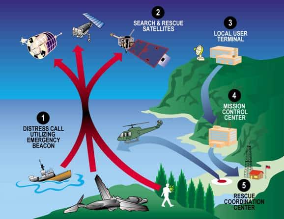
- The user activates the EPIRB. The EPIRB calculates its position using GPS and then transmits its identity and location to the COSPAS SARSAT network of satellites.
- One of the satellites detects the EPIRB signal. It is then sent throughout the network so that it can be forwarded to a Local User Terminal.
- The Local User Terminal receives the transmission and determines the correct control centre to send the signal on to.
- Once the signal reaches the Mission Control Center, they look up the beacon’s identity in their database. They then send all relevant details on to the Rescue Coordination centre.
- When the signal arrives at the Rescue Coordination Center, the actual rescue can be planned and search and rescue assets dispatched to the scene.
In summary, the signal from an EPIRB is sent across a network to a Rescue Coordination Center, who then sends helicopters, ships or other search and rescue assets to your location.
Once search and rescue craft get close, they home in on the precise location of the EPIRB. They can either home in directly on 406MHz, or they use the aeronautical emergency frequency of 121.5MHz.
The most modern EPIRBs now also transmit an AIS signal that can be picked up by other vessels. Most ships can’t home in on traditional EPIRB transmissions, but they can pick up AIS. They use AIS to home in on the precise location of an activated EPIRB.
What signal do EPIRBs send?
EPIRBs send out a couple of different signals. They use 406 MHz, 121.5 MHz, 161.975 MHz and 162.025 MHz.
Their main signal is on 406 MHz. This is the one that carries the initial distress up to satellites. 406 MHz is internationally designated as a frequency that can only be used for distress by satellite beacons.
The 406 MHz signal transmits the EPIRB’s identification number and, if GPS is fitted to the EPIRB, its location.
A secondary signal that a lot of EPIRBs use is on 121.5 MHz. This is the aeronautical distress frequency and is intended to provide a signal for rescue aircraft to home in on.
In the past, 121.5 MHz and 243 MHz were used to send signals up to satellites, however that has now been replaced by the use of 406 MHz. One particular reason for this is that it is much harder to eliminate false signals on 121.5 MHz because it is the aeronautical distress frequency. Satellites no longer monitor 121.5 MHz or 243 MHz.
The final signals that EPIRBs can transmit is AIS. The frequency for AIS is 161.975 MHz and 162.025 MHz, or VHF Ch 87b and 88b.
EPIRBs transmit their identity and GPS location through AIS so that it can be received by ships in the immediate vicinity. Ships do not routinely have the ability to track aeronautical distress frequencies, so including AIS gives the ability to be detected from surface vessels as well as from aircraft./
Do EPIRBs have GPS?
EPIRBs do not have to use GPS, but in order to comply with GMDSS requirements they must use some sort of global navigation satellite system (GNSS). They must…
“Be provided with a GNSS receiver for position fixes and an associated indication that GNSS signal reception is satisfactory or unsatisfactory”
Annex 24, IMO Resolution MSC.471(101)
The regulations state that any GNSS is suitable for use by EPIRBs. GPS is the most common and popular one in use today, but there are other options available.
Theoretically, EPIRBs could use any of the following:
- GPS (owned by the USA)
- GLONASS (owned by Russia)
- BeiDou (owned by China)
- Galileo (owned by the EU)
The requirements just mean that all EPIRBs will have a means of calculating their position with a satellite navigation system. This gives them the ability to transmit their position on 406 MHz, drastically reducing the time it takes to initiate a rescue.
Without GPS, it can take hours to locate an EPIRB as it can only be accomplished with the polar orbiting satellites. Geostationary satellites can only receive signals. They cannot locate the beacon.
Do EPIRBs have AIS?
EPIRBs do not currently need to have AIS fitted, but they will do in the future.
The regulations have been updated to include requirements for AIS in EPIRBs. Performance standards now state that EPIRBs must…
“Be provided with an Automatic Identification System (AIS) locating signal in accordance with the Recommendation ITU-R M.1371”
Annex 24, IMO Resolution MSC.471(101)
As this is a new requirement, there is an implementation period to give owners and manufacturers time to comply with the new regulations.
EPIRBs that are “installed on or after 01 July 2022” need to comply with these updated regulations.
You do not currently need to have AIS with your EPIRB. Given the changing regulations and the advantages of AIS though, there isn’t a reason to buy one without it now.
It enables surface vessels to detect signals directly from EPIRBs. Without AIS, signals need to travel via satellites, to control centers and then on to the searching vessels. Using AIS bypasses all of that and communicates with local ships directly.