What Is A Sextant Used For?
A sextant is a highly accurate scientific instrument, used for measuring the angle between two objects. Its best-known use is in celestial navigation when you measure the altitude of a celestial body. Celestial navigation is not the only situation where you can use a sextant though.
A sextant can be used for:
- Measuring the altitude of celestial bodies
- Finding a vertical sextant angle of a charted object
- Measuring horizontal sextant angles of multiple charted objects
- Using vertical sextant angles to find a clearing range
- Using horizontal sextant angles to find a danger angle
Sextants are simply a tool used for measuring angles. When used for navigation, you can apply those angles in any number of different ways to find your position and keep yourself safe.
Finding a line of position by measuring the altitude of a celestial body
The best-known use for a sextant is to find the altitude of a celestial body as part of a celestial fix.
You use the sextant to measure the angles between the horizon and any celestial body. Any celestial body will work. You can use the sun; the moon; planets; or stars. As long as the body you choose in is the nautical almanac, you will be able to perform the calculations you require.
A celestial fix is a complicated procedure, best explained with a video demonstration. I made the video below to cover the whole process, so you can watch that if you would like to know in detail how to find a line of position with a sextant.
If you don’t want to watch, then we can summarise the method instead. The principle of a celestial line of position is that you measure the altitude of a celestial body using a sextant, and compare it to the altitude that you expect the body to be, according to your almanac.
The difference between the observed altitude and the calculated altitude gives you a line of position that you can plot on the chart. Taking three observations gives you three lines of position, which can be used for a three-point fix.
The precision of the sextant is needed because each degree of error would give you an error of 60 nautical miles in your position.
Why is it useful to find a line of position from a celestial body?
In navigation, you need to be able to find a line of position from a celestial body because it is the only non-electronic way of fixing your position when out of sight of land.
The sextant is by no means as accurate as a GPS, but it is accurate enough to use as a backup if your GPS should fail.
Read more: How Accurate Is Celestial Navigation Compared To GPS?
Using the sextant to measure the altitude of celestial bodies gives you the most accurate measurement that it is possible to get with a handheld instrument. Nothing else is able to give you the same accuracy.
Finding a range by measuring the vertical sextant angle of a charted object
Branching away from celestial navigation, you can use the sextant for terrestrial navigation as well.
When you have a charted object with a known height, you can use the sextant and trigonometry to calculate your distance from the object, giving you a line of position.
A good example is a lighthouse, where a nautical chart will tell you the height of the focal plane of the light.
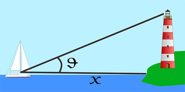
In the diagram above, you can use your sextant to measure the angle, θ.
The height of the lighthouse can found from the chart. You’ll need to apply the height of the tide to the charted height depending on how your chart references heights. For example, if heights are referenced to HAT, you will need to use the following formula:
Height = Charted Height + HAT – Current Height of Tide
Once you have found the current height of the lighthouse above the water level, and have measured the angle, θ, with your sextant, you can use trigonometry to calculate the distance to the lighthouse.
Range = Height of Lighthouse / Tan θ
With the range, you can then plot a line of position using normal chartwork techniques. You have a range, and a charted object, so you know you are somewhere along an arc of constant range from the charted object.
Using the sextant gives you precision when measuring a vertical angle that just wouldn’t be possible with other instruments. This is especially important when the height is small compared to the range.
You can measure the angle of a lighthouse that it 10s of meters tall, even when you are a few miles away. The sensitivity and precision of the sextant are essential when measuring such small angles.
Why are vertical sextant angles useful?
Using a sextant to measure vertical sextant angles allows you to get two lines of position off a single charted object.
You can calculate the range, and you can take a compass bearing.
With two lines of position, you can get a reasonable idea of your location. It isn’t yet enough to confirm your position because for that you would need a third line of position.
The only other way to get a range to use as a line of position is with radar. Radars are electronic equipment, that cost a lot of money to install. They are also subject to the same failures as all electronic equipment.
Once you have the skills to use a sextant to get a vertical sextant angle, you give yourself even more tools in your arsenal for coastal navigation.
Using horizontal sextant angles to find a line of position from two charted objects
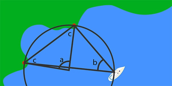
Turning your sextant on its side, you can use it to find horizontal sextant angles. These are exactly what they sound like. They are the horizontal angle between two charted features.
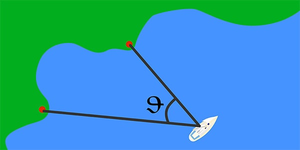
You can use a horizontal sextant angle to plot a line of position.
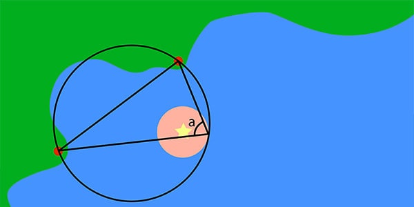
Horizontal sextant angles use circle theorems to plot lines of position. Specifically, the “angle at the centre theory”.
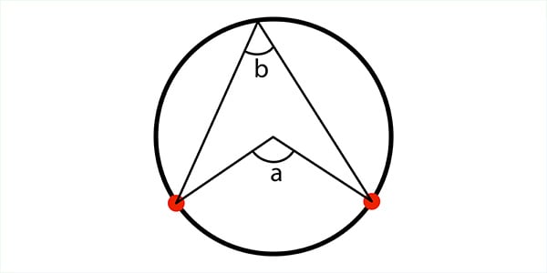
In the image above, circle theory tells us that the angle, “a”, will be twice the size of angle, “b”. You have used your sextant to measure angle “b”, so you can use mathematics to calculate the size of angle “a”.
Once you have found angle “a” you can use triangle theory to calculate the size of both angles “c”.
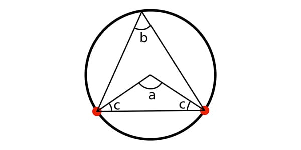
You can then use angle “c” to plot onto your chart and find the centre of the circle. Using the centre, and one of the charted features, as the radius, you can plot the entire circle. The circle is your line of position.
The horizontal sextant angle between two charted objects gives you a single line of position. You can use a third object to get three lines of position and a full three-point fix.
You take the angles between:
- Object 1 & object 2
- Object 2 & object 3
- Object 3 & object 1
An alternative to using three objects is to use the two objects as we did in the example. You can then use the bearings of both objects as well to give yourself a three-point fix.
Why are horizontal sextant angles useful?
Horizontal sextant angles are particularly useful because they give you the ability to fix your position independently of any other equipment.
Using three charted objects, you can fix your position using your sextant on its own. This is especially useful because it will give you an accurate position fix even when your boat’s compass is not working.
The sextant does not rely on any external inputs. It is purely a scientific instrument used to measure angles. Using the accuracy of a sextant allows you to plot extremely accurate lines of position using horizontal sextant angles.
Finding a clearing range using a vertical sextant angle of a charted object
While you can use a sextant to plot a line of position using vertical sextant angles, you can extend that use to find a clearing angle.
The principle of clearing angles is that as you get closer to a charted object, the angle that you measure will get bigger.
You can calculate the maximum angle that you want to keep yourself a safe distance away from a hazard.
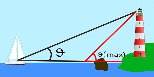
We already found a line of position using the angle, θ. As you are navigating closer to the coast, a clearing angle tells you the maximum that you can let θ get to while keeping yourself safe. We call that θ(max).
If I am on my sailing yacht, I can periodically check the angle between the top of the lighthouse and the surface of the water. As long as it is less than my pre-determined θ(max), I know that I am in safe water.
Why is it useful to work with vertical clearing angles?
Using a sextant to find a vertical clearing angle is especially useful for coastal navigation. If you know that you need to keep 0.25 nautical miles from a lighthouse to keep yourself safe, you can just calculate the angle that you are looking for.
It is then incredibly fast to measure the angle with your sextant and check it is less than your clearing angle.
The major advantage is that you do not need to constantly go back and complete trigonometry to find your distance from the lighthouse.
Again, the sextant is independent of all electronic navigational equipment making it an ideal backup for keeping yourself safe.
Assuming you have planned clearing angles during your passage planning stage, you can very quickly cross-check the safety margin that your GPS is giving you.
Using a horizontal sextant angle to find a danger angle with charted objects
In the same way that we worked backwards to find a vertical clearing angle, you can do the same thing with horizontal sextant angles.
The principles are the same as they were for calculating lines of position, but we work backwards to find a danger angle instead.
In the image above, I have plotted a 0.5 nautical mile ring around a danger. I then plotted a circle which runs through the two charted objects and the very edge of the danger area. The angle, “a” is found by measuring between the lines joining the edge of the danger area and the charted objects.
You then set your sextant the same as angle “a”.
As you approach the danger, you can observe the two charted objects, measuring the angle between them. The further away you are, the smaller the angle will be.
As you get close, the angle between the charted objects will get bigger. You know you are safe as long as the angle you measure stays smaller than angle “a”.
Why is it useful to use horizontal danger angles?
Horizontal danger angles are useful for coastal navigation in the same way vertical sextant angles are. They can keep you a safe distance away from dangerous water.
Again, they are completely independent of all electronics. If you lose your GPS and your radar, horizontal danger angles keep you safe using only your sextant.
With horizontal danger angles, the sextant isn’t the only tool that can accomplish it. You can simply set some dividers or anything else that can hold an angle to be the correct amount. Using a sextant will be one of the most accurate ways of doing it though.
The thing with danger angles is that they do not need to be measured accurately. You only need to know when you have crossed the danger angle. The advantage of using a sextant, however, is that whenever you take a measurement less than the danger angle, you can use the accurate measurement to complete a horizontal sextant angle plot and get an accurate line of position.
What else can you use a sextant for?
Sextants are useful any time you need to measure angles.
We have already discussed a few situations that make the most of the fine accuracy that a sextant can achieve. When accuracy isn’t too important, while you can use a sextant, other methods will be plenty accurate enough and allow you to get the job done quicker.
For example, doubling the angle on the bow. This is a method for finding your range from a fixed object using triangle theorems. You can use a sextant to measure the angle from the bow to the charted object, but the precision given by a sextant would be considered overkill.
When doubling the angle on the bow, you only need enough accuracy to know when the angle is doubled, to the nearest degree. The ship’s compass is usually accurate enough for this purpose.
Likewise, you could use a sextant to measure the relative bearing of different vessels to determine if a risk of collision exists. Again, using a sextant is overkill in this sort of situation. While it will give you a very precise answer, if you are relying on the sort of level of precision that a sextant will give you, it is safe to assume the risk of collision does exist.
Overall, the sextant is a precision instrument, used for measuring angles. When you need a high level of precision, it can be the ideal tool to use. When precision is not too important, other methods may be more efficient than the sextant.