Nautical Chart Symbols & Abbreviations: Nature Of Seabed
Nautical charts are filled with so much information that it is inevitable some things would be abbreviated.
One such abbreviation is for the terms describing the nature of the seabed.
For example, rather than writing the word “sand” hundreds of times on each chart, the universal abbreviation “S” is used instead.
All the abbreviations are contained within official publications such as “Chart 1” in the US, and “Chart 5011” in the UK.
To save you time, however, I have compiled a list of the most common ones I could find and put them together into a simple-to-read cheatsheet.
Please note: The cheat sheet should not be used for navigation as you should always consult official publications. It is a good starting point for making your own notes though.
You’ll find that I have broken the sheet down into sections, starting from the most commonly used at the top.
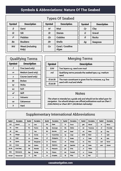
Types Of Seabed
There are a small number of internationally recognised abbreviations to describe the nature of the seabed on nautical charts.
Some charts may use their own versions of these abbreviations, but in general, if you know these then you will be able to work out the meaning on most charts.
As these are the most important description when it comes to the seabed, you’ll notice that all of these symbols are capitalised. The importance of this will become more apparent when we talk about qualifying terms in the next section.
| Symbol | Description |
|---|---|
| S | Sand |
| M | Mud |
| Cy | Clay |
| Si | Silt |
| St | Stones |
| G | Gravel |
| P | Pebbles |
| Cb | Cobbles |
| R | Rock; Rocky |
| Bo | Boulder(s) |
| Co | CoralCoralline Algae |
| Sh | Shells (skeletal remains) |
| Wd | Weed (including kelp) |
| Sg | Seagrass |
Qualifying Terms
With nautical charts, qualifying terms are used to add further detail for navigators to better understand the nature of the seabed.
For example, while the seabed type may be “M”, or mud, there may be a qualifying term attached to it telling you that it is “sy M”, or sticky mud.
Most qualifying terms can be used to describe multiple types of seabed, but there are some that are limited to sand, “f”, “m”, and “c” describing “fine”, “medium” and “course” respectively.
One thing you’ll notice about all the qualifying terms is that they are in lower case letters. This is done on purpose so that it is easier to differentiate them from the more general seabed symbols.
| Symbol | Description |
|---|---|
| f | Fine (sand only) |
| m | Medium (sand only) |
| c | Coarse (sand only) |
| bk | Broken |
| sy | Sticky |
| so | Soft |
| sf | Stiff |
| v | Volcanic |
| ca | Calcareous |
| h | Hard |
Layered Seabed (with examples)
Occasionally, you will find a seabed with two different characteristics layered on top of each other. This would be a layered seabed.
Layered seabeds are different to mixed seabeds because they are separated into distinct layers.
For example, you might find a layer of sand has accumulated over an underlying mud sea floor.
It is important to take note of layering on a chart because it can give you critical information for operations such as anchoring.
If you see that there is a layer of weed over an underlying mud seafloor, you will expect your anchor to have far less holding power than if there was no weed.
Layered seabeds are characterised with a “/” symbol, with the top layer listed first.
For example.
| Symbol | Description |
|---|---|
| S/M | Sand over mud |
| M/S | Mud over sand |
| Sh/S | Shells over sand |
| Co/S | Coral over sand |
| M/R | Mud over rocks |
Mixed Seabed Terms (with examples)
A mixed seabed is one in which different constituents are mixed together across the seafloor. It is different to the layered seabed, because the different elements are mixed together rather than being layered on top of each other.
To show a mixed seabed on a chart, the different constituent parts are listed in order, with the main constituent first.
For example, if you had a seafloor that is comprised mainly of sand, with some shells and pebbles mixed in, it would be written as:
S.Sh.P
The use of a full stop between the terms is optional, so the same mixture could also be written as:
S Sh P
Further examples of mixed seabeds are:
| Symbol | Description |
|---|---|
| S.Sh.P | Sand with shells and pebbles |
| M St | Mud with stones |
| G Cy | Gravel with clay |
| Cb.S.Sh | Cobbles with sand and shells |
| Si M | Silt with mud |
Supplementary Abbreviations
Up until this point, the abbreviations that we have discussed have been the international symbols and abbreviations.
While these are found on most charts, there may also be symbols and abbreviations that are specific to the national hydrographic office that has produced the chart.
For example, in the United States, NOAA maintains a list of supplementary abbreviations that they may use on their charts.
NOAA Supplementary Abbreviations
Charts produced by NOAA may use supplementary abbreviations that are specific to US charts.
Supplementary abbreviations may be used in the same way as international abbreviations. They can be layered or used to show different mixtures of seabeds.
The full list of these is published in Chart 1, but I have included a selection of them in the table below.
| Symbol | Description |
|---|---|
| Grd | Ground |
| Oz | Ooze |
| Ml | Mark |
| Sn | Shingle |
| Ck | Chalk |
| Qz | Quartz |
| Sch | Schist |
| Co Hd | Colar head |
| Mds | Madrepores |
| Vol Ash | Volcanic ash |
| La | Lava |
| Pm | Pumice |
| T | Tufa |
| Sc | Scoriae |
| Cn | Cinders |
| Mn | Manganese |
| Oys | Oysters |
| Ms | Mussels |
| Spg | Sponge |
| K | Kelp |
| Grs | Grass |
| Stg | Sea-tangle |
| Spi | Spicules |
| Fr | Foraminifera |
| Gl | Globigerina |
| Di | Diatoms |
| Rd | Radiolaria |
| Pt | Pteropods |
| Po | Polyzoa |
| Cir | Cirripedia |
| Fu | Fucus |
| Ma | Mattes |
| sml | Small |
| lrg | Large |
| rt | Rotten |
| str | Streaky |
| spk | Speckled |
| gty | Gritty |
| dec | Decayed |
| fly | Flinty |
| glac | Glacial |
| ten | Tenacious |
| wh | White |
| bl; bk | Black |
| vi | Violet |
| bu | Blue |
| gn | Green |
| yl | Yellow |
| or | Orange |
| rd | Red |
| br | Brown |
| ch | Chocolate |
| gy | Gray |
| lt | Light |
| dk | Dark |
| vard | Varied |
| unev | Uneven |