How To Measure Distances On A Nautical Chart
As an Amazon Associate, Casual Navigation earns from qualifying purchases.
One of the most unusual features of a nautical chart is that you will almost never find a scale bar.
This is because the scale used on a nautical chart is actually just the latitude scale.
To measure a distance on a nautical chart, you set your nautical dividers at the length you wish to measure and then transfer them to the latitude scale at the side, which will tell you the distance in terms of degrees and minutes of latitude.
Then, you transpose it to a distance in nautical miles using the conversion of 1 minute of latitude = 1 nautical mile.
The reason we use the latitude scale rather than a scale bar is that nautical charts have a tendency to distort images because they are representing a 2d projection of a 3d globe.
As you go further north or south, you’ll notice the images are stretched.
Fortunately, the latitude scale is also distorted, meaning that distances on a chart maintain the correct proportions according to that scale.
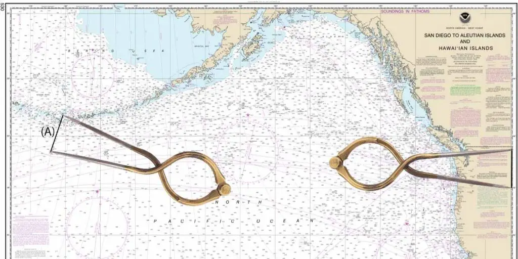
You just need to ensure that you use the latitude scale bar at the same latitude of the distance you wish to measure. In other words, move your dividers immediately left or right, but not up and down.
Pro Tip: Use the latitude scale to measure distances on a nautical chart, but ensure you use the same latitude as that which you wish to measure.
One of the most common mistakes that I have seen is students using the longitude scale instead of the latitude scale.
Parallels of longitude converge towards the poles meaning that the conversion of 1 minute = 1 mile only applies on the equator. As you head further north or south, each minute of longitude represents a distance greater than 1 mile so it cannot be used for measuring distances on a nautical chart.
Tools Required To Measure Distances On A Nautical Chart
The simplest way of measuring distances on a nautical chart is to use a set of nautical dividers.
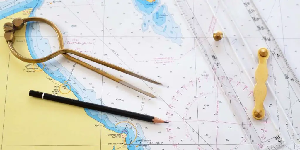
Nautical dividers are usually made of brass or steel, and give enough resistance so that they maintain the same setting as you transfer them across the chart.
You could improvise by physically measuring the distance with a ruler, but that can lead to the introduction of more errors as you transfer across the chart.
The other great advantage of using nautical dividers is that you can set their length along the latitude scale, for example at 5 miles. Then, you can “walk” them along a track line to lay off equidistant markings along your track.
Nautical dividers are split into two major types, one-handed and two-handed.
Single-Handed Nautical Dividers vs Two-Handed Nautical Dividers
As the name suggests, the difference between the two types of nautical dividers is the number of hands they are designed to be used with.

Two-handed nautical dividers (link to Amazon) look like a traditional set of compasses, with the pencil holder replaced by a second sharp point.
The idea is that you hold one arm in each hand, and stretch them out to measure the distance you require.
The major advantage of two-handed dividers is that they can measure greater distances as they can stretch much further apart than single-handed dividers.
Single-handed nautical dividers (link to Amazon) are similar to two-handed dividers except they have a circular section which allows you to squeeze them together with one hand to separate them and measure a distance.
Pro Tip: My favourite nautical dividers are these single-handed nautical dividers (link to Amazon).
They provide a far more natural navigation experience, allowing you to use the dividers in one hand while holding a pencil for writing notes in the other.
Although the arms do not separate as far as two-handed dividers, you can actually use them in two hands and pull the arms apart for the odd occasion that you need to measure greater distances.
Of course, if you find that you are frequently measuring long distances that require you to use both hands, you would be better off buying two-handed nautical dividers because they are smaller when folded and stored on your chart table.
Latitude vs Longitude For Measuring Distances On A Chart
The way we measure distances on a nautical chart is by taking advantage of the historical definition of the nautical mile.
“A nautical mile is precisely 1852m, which historically corresponded to 1 arc minute of latitude.”
Casual Navigation
At every parallel of longitude, we have a circle marking different latitudes. The circle generated at every parallel of longitude is the same size, meaning that they consistently maintain the relationship of 1 nautical mile = 1 arc minute across the surface of the earth.
Parallels of latitude, on the other hand, mark the locations of circles of longitude. As you get closer to the poles, those circles shrink. They are still 360°, but their physical length gets shorter as they converge on the poles.
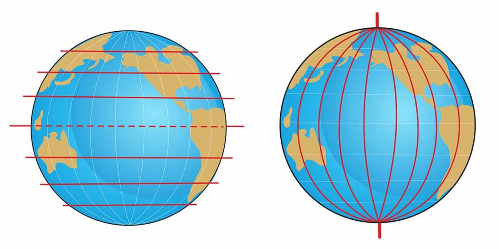
In the diagram above, you can clearly see the parallels of latitude are evenly spaced while the parallels of longitude converge on the pole.
The actual distance between the parallels of latitude (marked on the left and right sides of a nautical chart) is consistent.
The actual distance between the parallels of longitude (marked on the top and bottom of a nautical chart) shrinks as the lines converge towards the poles.
Use The Scale At Your Location
Although the latitude scale consistently represents the relationship of 1 arc minute of latitude = 1 nautical mile, the scale at the side of a nautical chart is not consistent across the chart.
This is due to the distortions caused by representing a 3d earth on a 2d chart.
Over a small area, the distortions are not very noticeable, however when you look at a chart covering an entire ocean the differences become very apparent.
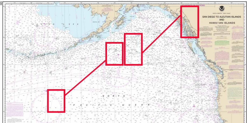
Further away from the equator, at the top of this chart, you can see the parallels of latitude are much further apart than they are at the bottom of the chart.
The physical distance between the lines is still the same, it has just been distorted due to the projection used.
What this means is that when you measure distances on a nautical chart, you must ensure that you use the latitude scale at the same latitude as the distance you wish to measure.
In other words, you need to move your dividers right or left, straight to the latitude scale. If you move them up or down, you may end up getting a distorted measurement.
This is the reason we use the latitude scale for measuring distances on a nautical chart, rather than a scale bar like you would find on a traditional map.
Although it sounds complicated, once you get used to it, measuring distances on a nautical chart will become second nature.