How Do EPIRBs Work?
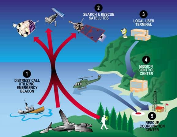
EPIRBs are a small part of a much larger system which includes beacons, satellites, mission control centres, aircraft and vessels. Together, they have saved hundreds of lives around the world.
EPIRBs (Emergency Position Indicating Radio Beacons) send distress signals to satellites, which forward it to ground stations and then on to search and rescue coordination centres. Rescue vessels are then dispatched, homing in on the signal from the beacon itself once they get close to you.
It sounds simple enough, but in reality, it is a long chain of communications that relies on the most modern technology work.
User segment of the EPIRB system
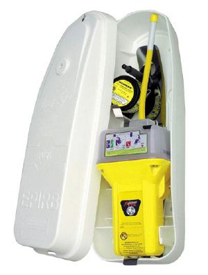
To understand how the system works, we start with the beacons themselves. This “user segment” is literally the part that the end user operates. The actual EPIRB beacon.
EPIRBs are the maritime specific beacon which sends a 406 MHz signal to satellites orbiting the earth.
Other beacons do also communicate with the satellites in the same way. ELTs (Emergency Locator Transmitters) and PLBs (Personal Locator Beacons) are two such examples. ELTs are designed for use in aviation, and PLBs are for personal use.
EPIRBs
An EPIRB is the maritime variant of the beacon, which complies with performance standards from the International Maritime Organisation (IMO).
ELTs
An ELP is the aviation variant of the beacon, which complies with performance standards from the International Civil Aviation Organisation (ICAO).
PLBs
A PLB is the personal variant of the beacon. It complies with national regulations for the country it is used in. For example, in the UK, it complies with regulations from OFCOM, the communications regulator.
Activating an EPIRB
As we are specifically focusing on EPIRBs in this article, I won’t go into further detail about ELTs or PLBs. You can assume they function in the same way as EPIRBs, but there will be some minor differences.
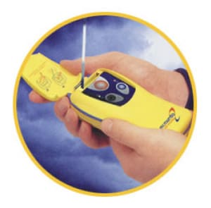
To activate an EPIRB, you just follow the instructions on the unit itself. Most of them will have a spring-loaded switch, held open with a pin. You can slide it one way to test, or remove the pin and turn it on.
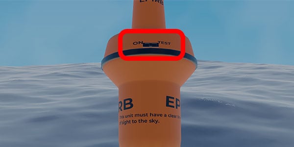
When you activate the EPIRB, it will use an internal GPS to determine its latitude and longitude.
Simultaneously, the beacon starts transmitting its distress signal on 406 MHz. It simply transmits its own identification code.
EPIRBs do not need to be programmed with anything else before transmission. The reason for this is that transmitting on 406 MHz means that it is a distress signal. All details about the vessel in distress are retrieved from the database that the EPIRB is registered with, using the identification code.
Once the GPS position is available, that is added to the transmission so that the beacon eventually transmits its identity and its position.
If the GPS signal is unavailable for any reason, the space segment can still determine the position of the beacon using multiple satellites.
The space segment of the EPIRB system
Upon activation, the 406 MHz signals from the EPIRB will be detected by satellites monitoring the entire surface of the earth.
The satellites used for the detection of EPIRBs are collectively known as the COSPAS-SARSAT constellation. COSPAS (Cosmicheskaya Sistema Poiska Avariynyh Sudov) is the Russian system and translates as “Space System for the Search of Vessels in Distress”. SARSAT (Search And Rescue Satellite-Aided Tracking) is the US system.
Together they are known as COSPAS-SARSAT because both systems have been built with complete interoperability in mind.
Contrary to popular belief, the COSPAS-SARSAT constellation is not actually a dedicated search and rescue constellation. Instead, it is just an instrument package that is flown on other satellites.
As the system is flown onboard other satellites, COSPAS-SARSAT makes use of multiple different orbits and configurations. Broadly speaking, we split them into three categories: LEOSAR; GEOSAR; and MEOSAR.
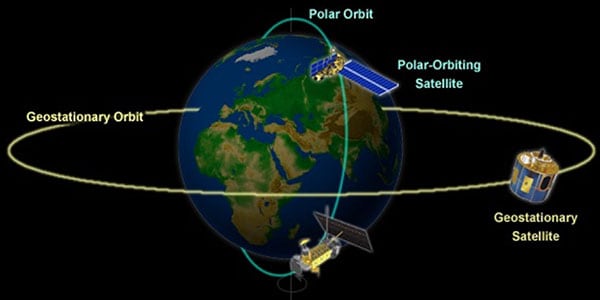
Low earth-orbiting search and rescue (LEOSAR) satellites
The SARSAT instrument package is flown on low earth-orbiting satellites that are primarily used for monitoring the weather and the climate.
These satellites are in polar orbits, at a relatively low altitude of around 850km. Their low altitude means that the footprint underneath each satellite is relatively small. Each one does not see a large area of the earth.
As they are in polar orbits though, they move relative to the surface of the earth. They are orbiting north-south, and the earth is spinning east-west. Over time, the entire surface of the earth is covered.
Although LEOSAR satellites may take time to detect an EPIRB transmission, their movement relative to the earth (and the EPIRB) is critical. It means that they can use doppler shift to mathematically calculate the position of the EPIRB.
LEOSAR satellites do not need GPS to determine the position of an EPIRB.
Geostationary orbiting search and rescue (GEOSAR) satellites
SARSAT instruments carried on geostationary satellites form the GEOSAR element of the constellation.
Geostationary satellites are in orbit around the equator, moving at the same rate that the earth spins. They complete one complete orbit every day. From an observer on the earth, the satellite is fixed in one position in the sky.
Geostationary orbits are at 35,786 km, so they are significantly higher than the LEOSAR orbits we discussed in the previous section.
The advantage of these high orbits is that they maintain a constant watch over a huge area on the earth’s surface. They are capable of detecting an activated EPIRB almost instantaneously.
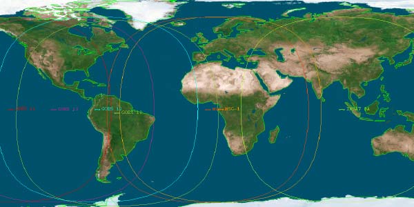
The disadvantage of GEOSAR orbits is that the satellite does not appear to move relative to the EPIRB. This means that they cannot use doppler shit to calculate the position of the beacon.
GEOSAR satellites are very good at detecting the initial transmission so that authorities can start using the registration database to narrow down the location.
Unless the EPIRB encodes its own GPS location into the transmission, LEOSAR satellites would also need to be utilised calculate the actual position of the beacon.
Medium-altitude earth-orbiting search and rescue (MEOSAR) satellites
The most recent element of the COSPAS-SARSAT constellation is satellites in medium-altitude orbits. These are typically between 29,000 km and 24,000 km.
MEOSAR combines the advantages of both LEOSAR and GEOSAR. You get the almost-instantaneous alerting like GEOSAR, as well as the ability to use doppler shift like LEOSAR.
To create the MEOSAR element, SARSAT payloads are carried on GNSS satellites in medium-altitude orbits. Examples include satellites within the following constellations:
- GPS III (United States)
- GLONASS K2 (Russia)
- Galileo (European Union)
Once the MEOSAR element is complete, every part of the earth will be visible from at least 4 MEOSAR satellites continuously. They will be able to instantaneously receive a 406 MHz distress signal with an encoded position, use trilateration to confirm the position, and relay it to ground stations.
Transmitting the signal to ground stations
Once the signal from an EPIRB has been received by the space segment, it needs to be transmitted back to the ground.
With GEOSAR satellites it is relatively simple as they are constantly monitored by ground stations.
LEOSAR satellites need to store transmissions that they pick up and transmit it on when they come within range of their ground stations. This is known as “store and transmit”, and adds some delay to the process.
MEOSAR satellites use a different technique, simply amplifying the signal and re-transmitting it. They are monitored in a way more similar to GEOSAR than LEOSAR. Their medium-altitude orbit means they are visible to a much greater surface area, so they spend minimal time outside of the range of their ground stations.
Whether the signal is received by LEOSAR, GEOSAR or MEOSAR, the result is the same. It gets relayed to ground stations and enters the ground segment of the EPIRB network.
The ground segment of the EPIRB system
The ground segment of the EPIRB system is made up of local user terminals; mission control centres; and rescue coordination centres.
Local user terminals
Local user terminals are the first stage in the ground segment. They are basically satellite monitoring stations, positioned around the world. Satellites transmit their signals down to local user terminals which begin processing the data.
Local user terminals perform slightly different analysis depending on whether they are connected with LEOSAR or GEOSAR satellites.
LEOSAR local user terminals perform doppler processing and basic error checking of the signals. They calculate the position of beacons that have been detected by multiple passes of LEOSAR satellites.
GEOSAR local user terminals only recover their satellite’s signals and perform basic error checking. As there is no relative movement between EPIRBs and GEOSAR satellites, there is no doppler processing that can be done.
No matter which local user terminal has received the signal, it is forwarded onto the next stage in the ground segment. The mission control centre.
Mission control centre
Mission control centres (MCC) are national centres that deal with EPIRB alerts for their country.
They receive alerts from their own local user terminals, as well as foreign mission control centres.
When the signal is first received by a mission control centre, they begin analysis. They will validate and match up simultaneous alerts while working out which country the distress alert belongs to.
For example, if a USMCC detects the activation of an EPIRB and they find it is from the UK, they will forward it on to the UKMCC.
Once the distress alert is received in the correct MCC, they cross-check the 406 MHz registration database to determine the identity of the vessel which has activated the EPIRB.
The database contains information that was submitted when the EPIRB was registered. It includes things like the name, callsign, owner and operator of the vessel. It gives search and rescue services all the relevant information that they need.
The final stage for the MCC is to send the alert, along with the registration information to the correct rescue coordination centre.
Rescue coordination centre
The bridge between the ground segment and the search and rescue segment is the rescue coordination centre (RCC).
The RCC receives the alert from the MCC and is then responsible for coordinating the actual rescue response.
In the US, the RCC for EPIRBs is the US Coast Guard. Different Coast Guard districts cover different geographical areas. If the emergency is outside of a particular Coast Guard district, they can liaise with local search and rescue providers.
For example, if the US Coast Guard received an alert that a US EPIRB has been activated near the UK, they would liaise with Falmouth Coastguard for the rescue. The US Coast Guard is still responsible for the rescue, but they will use partners around the world to best achieve that rescue.
The rescue coordination centre will often be a long way from the actual location of the distress. Their role is to coordinate the rescue, not to physically undertake it themselves.
This story “Falmouth MRCC Help Yacht Off Seychelles” is an example of how a remote RCC can enable the rescue. They diverted a commercial vessel to assist the yacht, as well as notifying the local coastguard.
Although Falmouth is thousands of miles away, they still coordinated the rescue by maintaining communications with vessels worldwide.
Search and rescue segment of the EPIRB system
The RCC is the first stage in the search and rescue segment of the EPIRB system. In the section above we discussed how it receives the alert from the MCC and then becomes responsible for conducting the rescue itself.
They dispatch different search and rescue assets depending on the nature of the distressed vessel.
Using the EPIRB registration database, they can determine how many search and rescue assets should be engaged. A small yacht does not need the same rescue assets as a cruise liner carrying 5000 people.
National RCCs have the authority to use different resources depending on what the government has assigned.
Search and rescue helicopters

When undertaking rescues near to the coast, search and rescue helicopters will often be the quickest assets that could be deployed.
A lot of countries have dedicated search and rescue helicopters that are routinely tasked by rescue coordination centres.
Other countries use military helicopters. Some will be dedicated military rescue helicopters, and others will be multipurpose.
Helicopters are very fast to reach the scene, and can directly rescue a limited number of casualties.
Even with larger vessels, helicopters are good assets to deploy because they can locate the scene quickly and provide a morale boost to those in distress.
Search and rescue aeroplanes

For operations out of range of search and rescue helicopters, aeroplanes can be used instead.
These aircraft can rapidly search huge areas of the ocean, locating the EPIRB that has been activated.
While they cannot winch people to safety themselves, they can drop liferafts or supplies down to survivors. They can also send an accurate position of the distress to nearby vessels who will be able to assist.
Search and rescue vessels
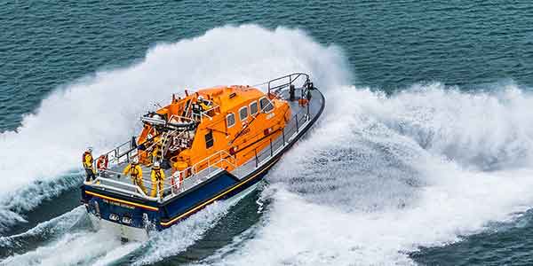
Most RCCs have access to a range of search and rescue vessels that can assist in searching for activated EPIRBs.
In the United States, the coastguard has a whole fleet of ships that can be deployed for search and rescue.
In the United Kingdom, the RNLI operates lifeboats around the coastline. Governmental vessels are available to assist, but the majority of rescues are completed by the RNLI charity.
Aside from dedicated search and rescue vessels, RCCs can usually call on military assistance if it is required. The navy of every country routinely practises for deployment in search and rescue missions.
Commercial vessels
As EPIRBs could be activated anywhere in the world, it is often the case that commercial vessels will be closest to the scene. Especially in the middle of an ocean, commercial ships could be the closest ship for hundreds of miles.
RCCs can call on any commercial vessel and request they divert for search and rescue purposes.
Passenger ships are particularly good for search and rescue purposes because they have comprehensive medical facilities onboard and can rescue a huge number of survivors. They also have a lot of personnel who can assist in the rescue itself once on scene.
On ships I worked on, we had a SAR Cooperation Plan on board, with a duplicate copy held by the coastguard. It listed all the ship’s emergency equipment that could be used in case of an emergency.
These plans are essential should the vessel itself ever get into difficulties, but they are also used if the vessel needs to undertake a rescue itself.
Locating the 121.5 MHz homing signal
When search and rescue craft reach the scene of an EPIRB activation, they then need to precisely locate the EPIRB itself.
Most EPIRBs emit a second signal on 121.5 MHz for this final homing stage. 121.5 MHz is the aeronautical distress frequency, and search and rescue craft carry equipment to locate it.
This “direction finding” equipment may be as simple as a handheld antenna that you rotate to determine the direction the signal is coming from. It gives you a bearing to follow to locate the EPIRB on the scene.
Although 121.5 MHz is known as the homing frequency on EPIRBs, the main 406 MHz signals can also be used for homing. The issue with homing in on the 406 MHz signal is that the equipment required is not as common as the 121.5 MHz homing equipment. Patrol aircraft may only be able to detect 121.5 MHz signals.
How do AIS EPIRBs work?
The newest addition to EPIRB performance standards is the requirement for them to transmit an AIS signal in addition to their other frequencies.
AIS operates on two channels, 87B and 88B. These are 161.975 MHz and 162.025 MHz respectively.
An AIS EPIRB transmits its identity and position on these AIS channels, which can be detected by any vessel with an AIS receiver.
Once detected, the AIS EPIRB shows up as a distinctive red circle with a cross in the middle.
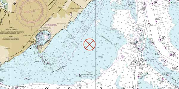
The important thing about AIS EPIRBs is that they can be detected by other vessels at sea. Regular 121.5 MHz and 406 MHz signals are not usually able to be detected by ships. This means that including an AIS signal can dramatically decrease the amount of time it takes to be rescued.
Registration of beacons
The final part of the puzzle of how EPIRBs work is their registration. Registering an EPIRB means that all the information that search and rescue authorities require is held on file.
Remember, the only thing that EPIRBs transmit is their own identity, and hopefully their position. There is no information about the vessel or the people in distress contained within the signal at all.
To get that information, the mission control centre consults the EPIRB registration database which needs to contain all the information that they require.
As part of the registration, you need to supply details including:
- Beacon identification numbers
- Name of the vessel the EPIRB is assigned to
- Type of vessel
- Maximum number of persons carried
- Identity numbers
- Radio equipment carried
- Name and address of owners
- Telephone, email and contact details of the owners
- The 24-hour emergency contact number of someone who should know the whereabouts of the beacon’s owner
The mission control centre will pass on all of these details to the rescue coordination centre in the event that your beacon is activated. It gives people in the rescue coordination centre the information they need to locate and rescue you quickly.
You are responsible for registering your beacon with the correct authority. There is a useful database of contact details at the COSPAS SARSAT International Beacon Registration Database, which you can visit by clicking here.
They direct you to check the country code of your beacon, then visit the appropriate authority to complete the registration directly.